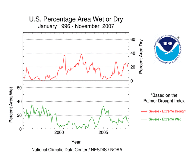
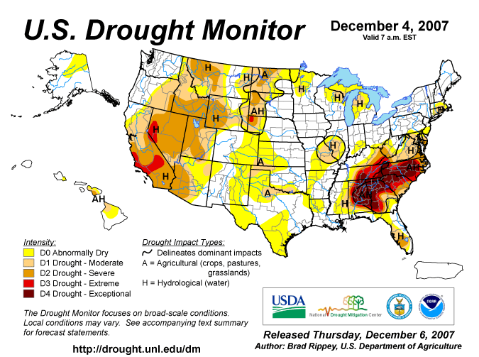
SOUTHEAST DROUGHT
According to the Southeast
Regional Climate Center, drought continued to be the top
climate story for almost all the Southeast in November. The end of
November is also the end of the North Atlantic hurricane season.
Earlier hopes that hurricanes would bring relief, partly encouraged
in September by Hurricane Humberto in Alabama and Georgia and
tropical storm Gabrielle in eastern North Carolina, were
unfulfilled. Indeed, in November the dominance of the Bermuda high
pressure system, helping to steer rain-bearing storms away from the
region, seemed to be even more marked. For numerous stations around
the Southeast November 2007 was the driest November in many years.
For several stations in Virginia and the Carolinas it was the
driest on record. Most notable was the record for downtown
Charleston, SC, where November 2007 had zero rain. The old November
record was 0.21 inch set in 1996, and the only other month which
has recorded zero precipitation was October 2000. Farther south the
lack of rain was less spectacular, it merely being the driest
November for the past few decades. If the current circulation
pattern persists, however, some spots might be on the way to new
annual records. For example, the total rainfall so far this year,
January through November, in Huntsville, Alabama was the lowest
since 1914.
Early in the month drought was still concentrated, as for previous
months, in the southern Appalachian Mountains. An expansion,
especially southward and eastward, took place followed by a slight
retreat for much of the area. The slight amelioration in the middle
of the month in Southern Florida however, was reversed, and severe
drought returned to that area.
According to the end-of-November U.S.
Drought Monitor discussion:
- USDA reports indicate that 81 percent of North Carolina's
pastures were rated in very poor to poor condition on November 25,
and pastures rated very poor to poor stood at 75 percent in
Virginia, 74 percent in South Carolina, and 71 percent in
Georgia.
- Another drought-related agricultural impact was delayed
emergence of winter wheat. Wheat planting was ahead of the 5-year
average in Georgia and North Carolina, while emergence trailed the
normal pace. In South Carolina, half of the wheat was planted (vs.
the 5-year average of 58 percent) by November 25, but the crop was
only 19 percent emerged (vs. the average of 43 percent).
In late November, the USDA declared 58 counties in Florida as
primary natural disaster areas due to drought.
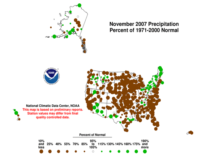
WESTERN DROUGHT
| As summarized by the
Western
Regional Climate Center, November precipitation across the West
was generally below normal except for parts of western Montana,
eastern Oregon and portions of Southern California and Arizona. The
Southwest was dry until the final day of the month. Palm Springs
had no rain through the first 29 days but ended up 468 percent of
normal for the month with 1.28 inches falling on the 30th. Most
monthly totals in Arizona all occurred on the final day of the
month. In Hawaii, thanks to a Kona low on the 4th, parts of Oahu
received over 10 inches of rain. Honolulu measured 3.81 inches on
the 4th which was 0.39 inch more than the total they had received
for January-October 2007 (3.42 inches). |

|
December 1st snowpack was well below normal in all regions
especially in the Sierra Nevada with most locations reporting no
snow at all. Roswell, NM, and El Paso, TX, have measured more
snowfall this season than ski resorts at Lake Tahoe. Isolated
locations of Montana, Washington and Oregon had near 90 percent of
normal snowpack.
MIDWEST DROUGHT
As explained by the Midwest
Regional Climate Center, dry weather persisted across most of
the region west of the Mississippi River, where November
precipitation was less than 25 percent of normal, and as low as 5
to 10 percent of normal in northwestern Iowa and southwestern
Minnesota. Parts of the Ohio Valley and a band from east-central
Illinois through the northern half of Ohio received normal to above
normal precipitation. Heavy rainfall in Kentucky the second and
fourth weeks of the month significantly reduced drought impacts in
the southeastern portion of the state, and at the end of the month
Extreme Drought (as defined by the U.S. Drought Monitor) existed in
all or parts of only nine counties in Kentucky.
NORTHEAST DROUGHT
As noted by the Northeast
Regional Climate Center, moderate drought conditions continued
in eastern Connecticut, Rhode Island, central Maryland and southern
Delaware, while severe drought conditions persisted in southwestern
West Virginia and Maryland's Eastern Shore. Precipitation totals
varied from north to south, with Delaware the driest, at 43% of
normal, and Maine the wettest, with 181% of the normal November
precipitation.
OTHER AREAS
According to the end-of-November U.S.
Drought Monitor discussion:
- In Texas, the percentage of the winter wheat crop rated very
poor to poor by USDA rose from 29 percent on October 28 to 53
percent on November 25. During the same 4-week period, Oklahoma
wheat rated very poor to poor increased from 18 to 30 percent,
while Kansas and Colorado wheat rated very poor to poor climbed
from 10 to 15 percent. By November 25, topsoil moisture rated very
short to short in Kansas stood at 100 percent in the southwest, 86
percent in the south-central region, 82 percent in the west-central
region, and 72 percent in the northwest. (The Kansas state average
was 53 percent very short to short on topsoil moisture.) Wheat was
struggling to grow on the southern High Plains, where Texas'
emergence stood at 70 percent on November 25, compared to the
5-year average of 85 percent. Similarly, Oklahoma's wheat was 83
percent emerged, compared to the 5-year average of 95 percent.
- Another complication of the Plains' dry autumn has been a rash
of grass fires. During the week ending November 23, the Aetna fire
burned 5,000 acres of vegetation in southern Kansas, while the Wild
Hog fires (two separate incidents) charred at least 3,400 acres in
northern Texas.
|


