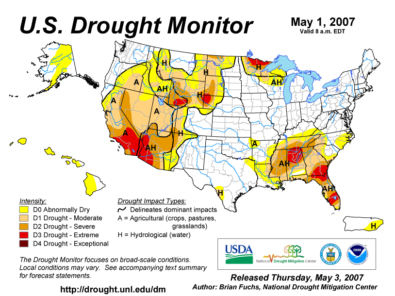
At the end of April
extreme drought was concentrated in the Southwest, the western High
Plains, northern Minnesota, and the Southeast. Drought and abnormal
dryness covered a broad swath from the Southwest through the
northwestern Plains into the upper Midwest, as well as another area
in most of the Southeast (May 1 Drought
Monitor). Conditions in southern California and southwestern
Arizona continued to deteriorate.
Storm systems throughout the month brought much needed
precipitation to the Plains and upper Midwest and eliminated the
drought conditions that had persisted for many months.
In the Southwest, Southeast and upper Midwest, soil
moisture was low. At the end of the month vegetation
was stressed over a large part of the country. Streamflow
was low in a wide area of the Southeast.
|
|
Fires consumed over
50,000 acres in the Everglades in Florida in April. Low water
levels in southern Florida delayed construction activities, caused
increased silt in the intake of water supply systems, affected
sales of landscape and horticulture materials, and led to more
severe water usage restrictions. Alligators are being seen more
frequently as they move in search of wetter habitat.
In central California water deliveries are being postponed, and
farmers were affected by poor pastures and water shortages.
Governor Arnold Schwarzenegger warned the state to plan for drought
because the winter was extraordinarily dry. He also urged residents
to conserve water.
Twenty-one counties in southeastern Georgia are in a state of
emergency due to extreme fire danger from drought. A wildfire in
the southeast part of the state was the largest in the history of
Georgia.
Large ships on Lake Superior carried lighter loads to avoid
striking the bottom of the lake. Recreational boats and sailboats
had difficulty on Lake Superior because of low water levels. The
water became so shallow that rowers in the Duluth, Minnesota Rowing
Club could touch the bottom with their oars.
Impacts in drought-stricken areas have been collected and
summarized by county at the National Drought Mitigation Center's
Drought Impact Reporter.
|


