Contents Of This Report:
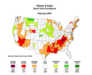
Map showing Palmer Z Index

Top of Page National Overview

  • A file containing the national monthly percent area severely dry and wet from 1900 to present is available for the severe to extreme and moderate to extreme categories.
  • Historical temperature, precipitation, and Palmer drought data from 1895 to present for climate divisions, states, and regions in the contiguous U.S. are available at the Climate Division: Temperature-Precipitation-Drought Data page in files having names that start with "drd964x" and ending with "txt" (without the quotes).


Top of Page Detailed Drought Discussion


At the end of February extreme hydrologic drought was concentrated in Texas, Wyoming, and northern Minnesota. Drought and abnormal dryness covered a broad swath from central and southern California through the northwestern Plains into the upper Midwest (February 27 Drought Monitor). Drought and abnormal dryness continued in Florida and increased in the central and southern Appalachians. In southern California and the upper Midwest, soil moisture was low. Vegetative health had become more stressed in the West. Streamflow was low in the East, especially in Tennessee, in parts of the Plains, and in Wyoming.

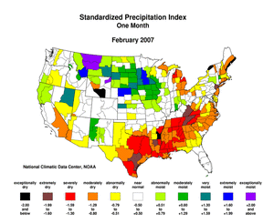
Map showing Standardized Precipitation Index

In Texas and Florida mandatory or voluntary water restrictions were in place in several municipalities. Private water wells were becoming dry in Texas. Burning bans were common in drought-stricken areas, and wildfires reduced forage in western Nebraska and increased in number in Florida. The hay supply in the central part of the country was 20 percent of average, leading to increased prices and abnormal selling of livestock at auctions. The killing of livestock and pets by wild animals in southcentral Texas increased as the wildlife searched for new food and water sources during the continuing drought. Dryness has increased the salinity of Virginia's James River and the Chesapeake Bay permitting the growth of parasites that are harmful to oysters; in some areas the oyster death rate was 90 percent. Impacts in drought-stricken areas have been collected and summarized by county at the National Drought Mitigation Center's Drought Impact Reporter.


Top of Page State/Regional/National Moisture Status


A detailed review of drought and moisture conditions is available for all contiguous U.S. states, the nine standard regions, and the nation (contiguous U.S.):

STATES:
Alabama Arizona Arkansas California Colorado Connecticut
Delaware Florida Georgia Idaho Illinois Indiana
Iowa Kansas Kentucky Louisiana Maine Maryland
Massachusetts Michigan Minnesota Mississippi Missouri Montana
Nebraska Nevada New Hampshire New Jersey New Mexico New York
North Carolina North Dakota Ohio Oklahoma Oregon Pennsylvania
Rhode Island South Carolina South Dakota Tennessee Texas Utah
Vermont Virginia Washington West Virginia Wisconsin Wyoming


REGIONS:
Northeast Region East North Central Region Central Region
Southeast Region West North Central Region South Region
Southwest Region Northwest Region West Region
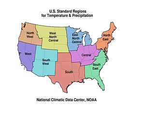
Map showing the nine U.S. standard regions
NATIONAL:
Contiguous U.S.


Top of Page Pre-Instrumental Perspective


There is no Febuary 2007 Paleoclimatic Perspective

Citing This Report

NOAA National Centers for Environmental Information, Monthly Drought Report for February 2007, published online March 2007, retrieved on April 19, 2024 from https://www.ncei.noaa.gov/access/monitoring/monthly-report/drought/200702.