U.S. Drought Highlights:

- On the national scale, severe to extreme drought affected about 9 percent of the contiguous United States as of the end of January 2006.
- Moderate to extreme drought affected about 22 percent of the contiguous U.S.
- The month was drier than normal across a broad swath of the country from the Southwest to the Great Plains, across much of the Gulf Coast, and into the coastal Southeast. About 8 percent of the contiguous U.S. was very dry (had precipitation in the bottom 10th percentile of the historical record).
- Above-normal precipitation continued to erode the drought areas in the Pacific Northwest. The month was wetter than normal across the drought areas from northeast Texas to northern Illinois, but it was not enough to compensate for the significant deficits of the last 10 months.
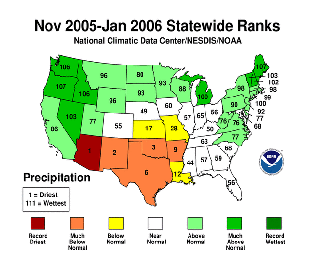
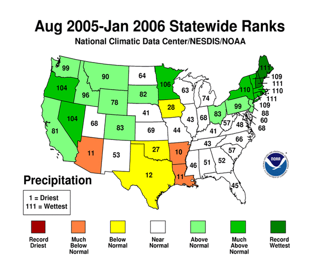
- The January dryness aggravated long-term drought in the Southwest and southern Plains (3 to 6 to 9 months). Long-term moisture deficits persisted across parts of the southern Plains to mid-Mississippi Valley (last 9 to 12 months) and West into the northern High Plains and central Plains (last 48 to 60 months).
Please Note: The data presented in this drought report are preliminary. Ranks, anomalies, and percent areas may change as more complete data are received and processed.
National Overview
On the national scale,
- severe to extreme drought affected about 9 percent of the contiguous United States as of the end of January 2006, an increase of less than 1 percent compared to last month
- about 22 percent of the contiguous U.S. fell in the moderate to extreme drought categories (based on the Palmer Drought Index) at the end of January
- on a broad scale, the previous two decades (1980s and 1990s) were characterized by unusual wetness with short periods of extensive droughts, whereas the 1930s and 1950s were characterized by prolonged periods of extensive droughts with little wetness
- about 14 percent of the contiguous U.S. fell in the severely to extremely wet categories at the end of January
- a file containing the national monthly percent area severely dry and wet from 1900 to present is available
- historical temperature, precipitation, and Palmer drought data from 1895 to present for climate divisions, states, and regions in the contiguous U.S. are available at the Climate Division: Temperature-Precipitation-Drought Data page in files having names that start with "drd964x" and ending with "txt" (without the quotes).
Regional Overview
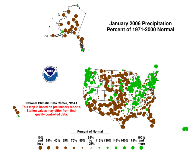
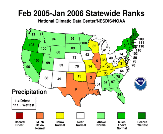
January 2006 was drier than normal across a broad swath of the country from the Southwest to the Great Plains, across much of the Gulf Coast, and into the coastal Southeast. About 8 percent of the contiguous U.S. was very dry (had precipitation in the bottom 10th percentile of the historical record).
Above-normal precipitation continued to erode the drought areas in the Pacific Northwest. The month was wetter than normal across the drought areas from northeast Texas to northern Illinois, but it was not enough to compensate for the significant deficits of the last 10 months.
The January precipitation pattern at the primary stations in Alaska was mainly drier than average, and at many stations much drier than average. Across Hawaii, the precipitation pattern was drier than average at the stations in Maui but mixed elsewhere. In Puerto Rico, the precipitation signal was mixed, based on National Weather Service radar estimates of precipitation. January streamflow averaged near to above normal for Puerto Rico and the Hawaiian Islands.

The January dryness aggravated long-term drought in the Southwest and southern Plains (3 to 6 to 9 months). Long-term moisture deficits persisted across parts of the southern Plains to mid-Mississippi Valley (last 9 to 12 months) and West into the northern High Plains and central Plains (last 48 to 60 months).
Some regional highlights:
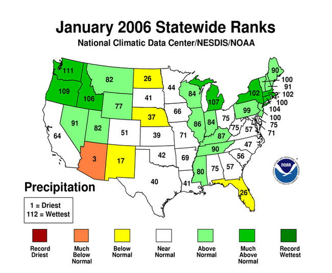
- Several states had the tenth driest, or drier, month in January and also for multi-month seasons (November-January, August-January, February-January and others). These states include:
- Arizona had record dry conditions statewide for several seasons back to September-January.
- Arkansas had the driest October-January.
- Stations in Texas and Arizona had the longest number of consecutive days without measurable precipitation, and Key West, Florida reported the longest run of days with less than a tenth of an inch of rain.
- Numerous wildfires throughout the month burned across several states in the central and southern Plains. Since the beginning of the year, over 3700 fires have charred more than 330,000 acres.
- The drought in Texas and New Mexico ravaged the winter wheat crop which is a major source of food for cattle, and this was forcing many ranchers to sell calves prematurely (Clovis News Journal, 1/26). In January, Governor Perry declared a drought disaster in all 254 Texas counties. According to Texas Cooperative Extension reports, more than 90 percent of the state's range and pastures were in extreme, stressed condition, and more than 90 percent of the wheat statewide was poor to very poor. Texas drought losses reached an estimated $1.5 billion this month (AgNews, 1/26).
- End-of-month and month-averaged soil moisture conditions, based on model computations (CPC-1, CPC-2, MRCC), were drier than normal across a broad swath from the southern Plains to the central Plains and western Great Lakes. From this core area, dry soil moisture conditions extended into the southwestern and southeastern U.S. The models also indicated dry soil moisture conditions in parts of Alaska and Hawaii, and near the surface and at depth from Nebraska and Kansas to the mid- and upper-Mississippi Valley.
- Streamflow levels were below seasonal norms across much of the southern Plains to mid-Mississippi Valley, and parts of the central Plains, Gulf Coast, and Southwest, as computed by models and based on USGS observations.
- Above-normal precipitation continued eroding the drought areas of the Pacific Northwest, but worsening drought conditions in the Southwest increased the western U.S. drought percentages (PDI December, January). About 17 percent of the western U.S. (Rockies westward) fell in the moderate to extreme drought category (as defined by the Palmer Drought Index) as of the end of January. Aggregated reservoir levels in the West (provided by the USDA) reflected the long-term precipitation deficits in many states.