| Contents Of This Report: |
 |

|

|
|
|
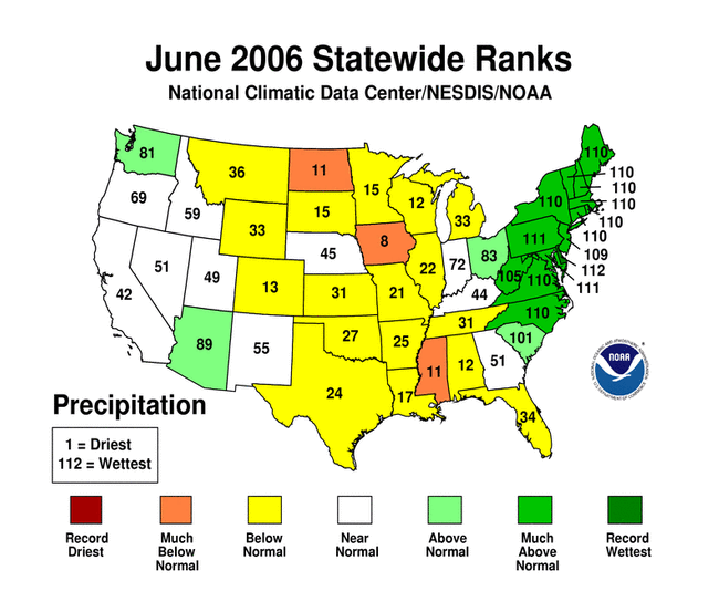
Dryness was observed in
June over much
of the country west of the Appalachians. The Southwest, western
Texas, western High Plains and the south Atlantic states have
experienced very dry conditions for the last
several months. The most severe conditions at the end of June
were in the Desert Southwest and
western Plains, and along parts of the western Gulf coast.
About 9 percent of the contiguous U.S. was very
dry (i.e., precipitation in the bottom 10th percentile of the
historical record).
Coupled with the very dry conditions were continuing high temperatures in the Southwest and western Plains. The combination of high temperatures and very little precipitation led to extreme drought as defined by the Palmer Z Index. Heavy rain near the end of the month in the mid-Atlantic States alleviated dry conditions, but dryness continued in most of the Southeast.
The June precipitation pattern at the primary stations in Alaska was below normal in most of the southeast part of the state. Across Hawaii, the precipitation pattern remained dry in the Northwest and became progressively drier towards the Southeast. In Puerto Rico, the month was predominantly dry in the central and western interior areas and along the northeast coast, based on National Weather Service radar estimates of precipitation. |
Some regional highlights:
|


|
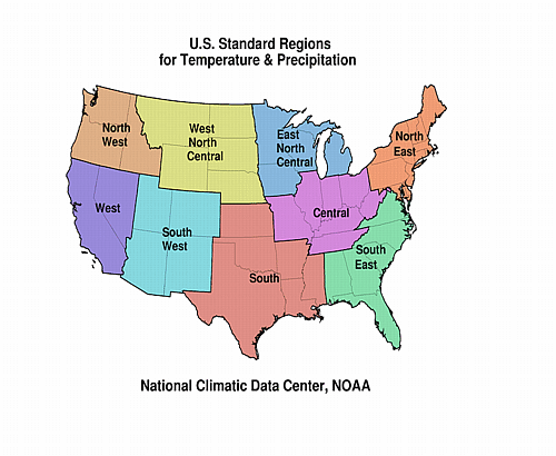
| A detailed review of
drought and moisture conditions is available for all contiguous U.S.
states, the nine standard regions, and
the nation (contiguous U.S.): STATES: REGIONS:
|
|
|
|
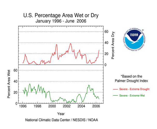
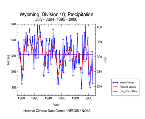
| The past year has seen a deepening of the long-term drought conditions that have persisted since late 1999 in southern Wyoming. Since July 2005, precipitation in Wyoming Division 10 (Upper Platte basin) has been below normal in 10 of 12 months, totaling only 73% of normal during the period. Both the Palmer Hydrological Drought Index (PHDI) and Palmer Drought Severity Index (PDSI) for Division 10 have values below -4 for late June 2006, indicating "extreme drought". |
 large image |
|
 large image  large image |
| The graph below (annual values in light blue, 5-year weighted average in dark blue) shows the annual (July-June) precipitation, 1896-2006, for Wyoming Division 10. The value for 2006 (8.55 inches) is the 5th lowest since 1896. The most persistent multi-year drought, with five consecutive years of below-normal precipitation, was 2000-2004. There were also several four-year droughts, including 1933-1936 (the Dust Bowl) and 1953-1956. The 1950s drought (indicated with the orange arrow) is similar to the present one in that several below-normal years were followed by an average year (1957, 2005), and then a return to drought conditions, which in the 1950s lasted for four more years. The 1950s drought and the 2000-2004 drought were also similar in overall severity. |
 large image (50 KB) |
The graph to the left also shows a 481-year tree-ring record (1520-2000; annual values in light red; 5-year smoothed values in dark red) that corresponds well to the variability in July-June precipitation. This record is the average of four tree-ring chronologies (Douglas-fir and pinyon pine) from Wyoming and Colorado. The correlation between the annual values of the tree-ring record and July-June precipitation is 0.633, indicating a high degree of shared variance. The tree-ring record captures the multi-year variability of the observed precipitation record particularly well. |
| The tree-ring record, as a proxy for precipitation, can put the annual precipitation variability of the last century in southern Wyoming into a much longer perspective. The tree rings indicate that about a dozen individual years prior to 1896 had lower tree growth than any year since then, suggesting these were years with annual precipitation lower than the lowest values in the past century. Turning to multi-year events, the average ring-width anomalies for the four-year periods 1665-1668 and 1845-1848 (red arrows) are very similar to that for 1953-1956, suggesting that those periods were droughts of similar severity to the 1950s. There are also four different periods before 1896 when the ring-width index was below average for more than five years in a row, including a nine-year period just before the start of the instrumental record (1886-1894; yellow arrow). |
Resources:
Reference:
|