U.S. Drought Highlights:

- On the national scale, severe to extreme drought affected about 6 percent of the contiguous United States as of the end of November 2005.
- Moderate to extreme drought affected about 18 percent of the contiguous U.S.
- The month was much drier than normal across a broad swath of the country from the Southwest to the southern Plains, with 13 percent of the contiguous U.S. very dry (in the bottom 10th percentile of the historical record). Parts of the Southeast, Midwest, and northern High Plains were also drier than normal.
- The November dryness aggravated long-term drought in the southern Plains to Lower Great Lakes and parts of the Ohio Valley (2 to 6 to 9 months). Long-term moisture deficits (last 48 to 60 months) persisted across parts of the West into the northern High Plains and central Plains.
Please Note: The data presented in this drought report are preliminary. Ranks, anomalies, and percent areas may change as more complete data are received and processed.
National Overview
On the national scale,
- severe to extreme drought affected about 6 percent of the contiguous United States as of the end of November 2005, an increase of about 1 percent compared to last month
- about 18 percent of the contiguous U.S. fell in the moderate to extreme drought categories (based on the Palmer Drought Index) at the end of November
- on a broad scale, the previous two decades (1980s and 1990s) were characterized by unusual wetness with short periods of extensive droughts, whereas the 1930s and 1950s were characterized by prolonged periods of extensive droughts with little wetness
- about 12 percent of the contiguous U.S. fell in the severely to extremely wet categories at the end of November
- a file containing the national monthly percent area severely dry and wet from 1900 to present is available
- historical temperature, precipitation, and Palmer drought data from 1895 to present for climate divisions, states, and regions in the contiguous U.S. are available at the Climate Division: Temperature-Precipitation-Drought Data page in files having names that start with "drd964x" and ending with "txt" (without the quotes).
Regional Overview
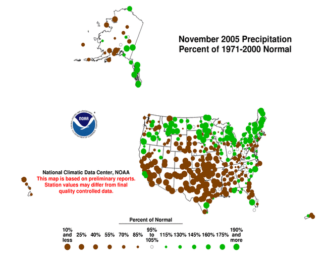
November 2005 was much drier than normal across a broad swath of the country from the Southwest to the southern Plains, with 13 percent of the contiguous U.S. very dry (in the bottom 10th percentile of the historical record). Parts of the Southeast, Midwest, and northern High Plains were also drier than normal.
The November precipitation pattern at the primary stations in Alaska was drier than average in the central to southwest parts of the state, and wetter than normal in the southeast and along the northern coast. Across Hawaii, the precipitation pattern was mostly drier than average. In Puerto Rico, the precipitation signal was mixed, based on National Weather Service radar estimates of precipitation. November streamflow averaged near normal for Puerto Rico and the Hawaiian Islands.
he November dryness aggravated long-term drought in the southern Plains to Lower Great Lakes and parts of the Ohio Valley (2 to 6 to 9 months). Long-term moisture deficits (last 48 to 60 months) persisted across parts of the West into the northern High Plains and central Plains.

The November dryness aggravated long-term drought in the southern Plains to Lower Great Lakes and parts of the Ohio Valley (2 to 6 to 9 months). Long-term moisture deficits (last 48 to 60 months) persisted across parts of the West into the northern High Plains and central Plains.
Some regional highlights:
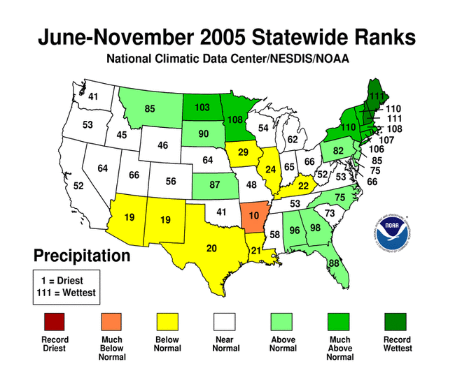
- Several states had the tenth driest, or drier, month in November and also for multi-month seasons (September-November, June-November, December-November and others). These states include:
- Record or near record dry conditions were reported at stations in Illinois (March-November) and Oklahoma (November).
- The Arklatex (southwestern Arkansas, southeastern Oklahoma, northeastern Texas) experienced the driest March-November in the 111-year record.
- November was extremely dry for parts of Oklahoma, especially the central sections. Governor Brad Henry issued a statewide burning ban November 15, with several large wildfires burning in the state near the end of the month. Governor Henry subsequently asked U.S. Agriculture Secretary Mike Johanns to expand a previously issued disaster designation to include all 77 Oklahoma counties because of drought and wildfires (AP).
- The moisture deficits in southwestern Missouri have lowered small ponds and stock ponds to well below normal levels. Drought in Arkansas had brought lake levels so low that some towns were studying measures to ensure a stable water system supply (Arkansas Democrat-Gazette). In central North Carolina, the city of Raleigh implemented mandatory water conservation measures.
- End-of-month and month-averaged soil moisture conditions were drier than normal across a broad swath from the southern Plains and Southeast to the Ohio Valley, a band from the central Plains to the Great Lakes, and parts of the West, based on model computations (CPC-1, CPC-2, MRCC). The models also indicated dry soil moisture conditions in parts of Alaska and Hawaii, and near the surface and at depth from Iowa to the western Great Lakes.
- Streamflow levels were below seasonal norms across much of the southern Plains to Ohio Valley states, from the central Plains to the Lower Great Lakes, and parts of the Southeast and West, as computed by models and based on USGS observations.
- Aggregated reservoir levels in the West (provided by the USDA) reflected the long-term precipitation deficits in many states. About 18 percent of the western U.S. (Rockies westward) fell in the moderate to extreme drought category (as defined by the Palmer Drought Index) as of the end of November, mainly reflecting continued dryness in the Pacific Northwest.