U.S. Drought Highlights:

- On the national scale, severe to extreme drought affected about 4 percent of the contiguous United States as of the end of December 2004.
- Moderate to extreme drought affected about 6 percent of the contiguous U.S.
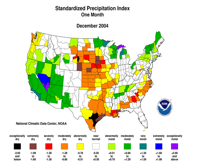
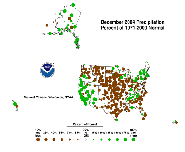
- December was another dry month across the Pacific Northwest, northern Rockies, and northern Plains. December was also drier than normal across much of the central and southern Plains and parts of the Southeast.
- Much of the southwestern U.S. drought region was wetter than normal for the fourth month in a row, effectively ending the meteorological drought in some areas according to the Palmer Drought Severity Index.
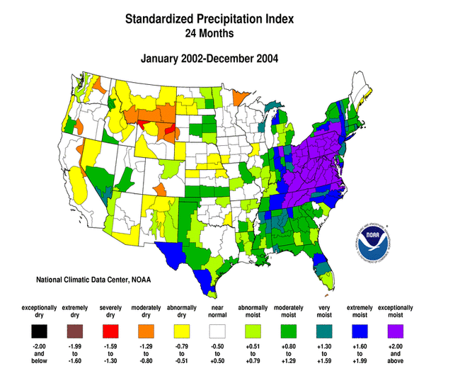
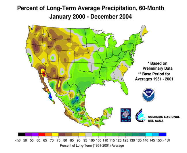
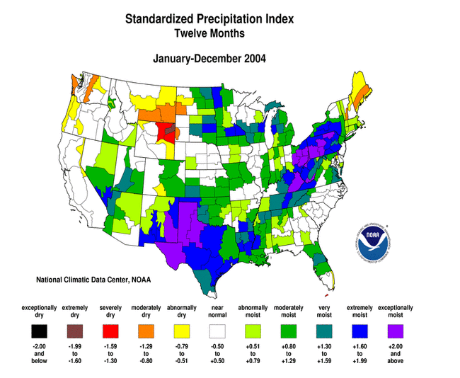
- Long-term moisture deficits (last 24 to 36 to 60 months) persisted across much of the West into the northern High Plains and central Plains.
Please Note: The data presented in this drought report are preliminary. Ranks, anomalies, and percent areas may change as more complete data are received and processed.
National Overview
On the national scale,
- severe to extreme drought affected about 4 percent of the contiguous United States as of the end of December 2004, about the same as last month
- about 6 percent of the contiguous U.S. fell in the moderate to extreme drought categories (based on the Palmer Drought Index) at the end of December
- on a broad scale, the previous two decades (1980s and 1990s) were characterized by unusual wetness with short periods of extensive droughts, whereas the 1930s and 1950s were characterized by prolonged periods of extensive droughts with little wetness (see graph below right)
- about 23 percent of the contiguous U.S. fell in the severely to extremely wet categories at the end of December
- a file containing the national monthly percent area severely dry and wet from 1900 to present is available
- historical temperature, precipitation, and Palmer drought data from 1895 to present for climate divisions, states, and regions in the contiguous U.S. are available at the Climate Division: Temperature-Precipitation-Drought Data page in files having names that start with "drd964x" and ending with "txt" (without the quotes).
Regional Overview
December was another dry month across the Pacific Northwest, northern Rockies, and northern Plains. December was also drier than normal across much of the central and southern Plains and parts of the Southeast. But much of the southwestern U.S. drought region was wetter than normal for the fourth month in a row, effectively ending the meteorological drought in some areas according to the Palmer Drought Severity Index.
The December precipitation pattern at the primary stations in Alaska was mixed but mostly wetter than normal. The pattern was also mixed in Hawaii, but most of the stations were drier than normal. In Puerto Rico, the southeast and parts of the northern and western areas were drier than normal, based on National Weather Service radar estimates of precipitation and on Cooperative station precipitation reports for the last 4 weeks and 8 weeks. December streamflow averaged near normal for Hawaii and Puerto Rico.

Long-term moisture deficits persisted in many areas. Much of the central and northern Rockies were dry at the 12 to 24 month timescales. Many Alaska stations, especially in the central and eastern interior regions, were drier than normal at the 12 month timescale. Severe moisture deficits were evident at the 36 to 60 month timescales across much of the West into the northern High Plains and central Plains. These long-term hydrological drought conditions are reflected in the January 4 United States Drought Monitor map.
Some regional highlights:
- End-of-month and monthly averaged soil moisture conditions were drier than normal across parts of the central and northern Rockies and High Plains, the Pacific Northwest, eastern Alaska, and near the surface and at depth across parts of the central Plains to the Great Lakes, based on model computations (CPC-1, CPC-2, MRCC).
- Streamflow levels were below seasonal norms across a few parts of the Pacific Northwest, and central and northern Rockies and Great Plains, both as computed by models and based on USGS observations.
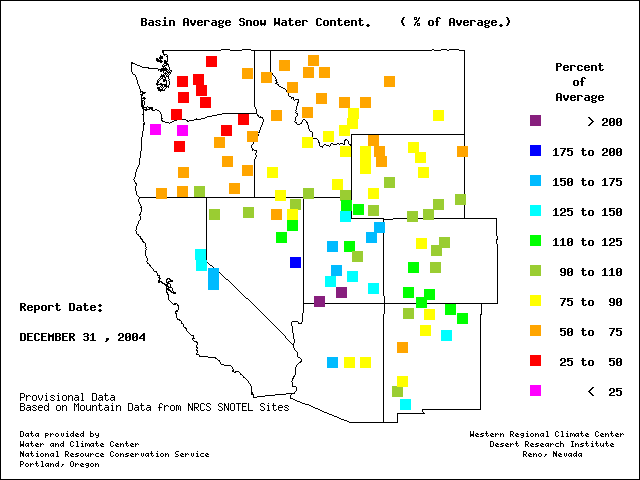
- Snow water content of the western mountain snowpack contrasted sharply from south to north. End-of-December snowpacks in parts of Arizona, Nevada, central California and Utah were above average, while snowpacks in Oregon, Washington, Idaho, Montana and the east slopes of the northern Rockies were significantly below average. This pattern, which is also apparent in water-year-to-date precipitation anomalies, reflected a southerly track of winter storms across the region for the last three months.
- Reservoir levels in most of the western states continued well below seasonal normals. Although long-term (out to 5-years) moisture conditions remained dry across much of the West, drought conditions have improved in recent months. The percent area of the western U.S. (Rockies westward) experiencing moderate to extreme drought (as defined by the Palmer Drought Index) decreased to about 10%.