U.S. Drought Highlights:

- On the national scale, severe to extreme drought affected about 10 percent of the contiguous United States as of the end of February 2004
- moderate to extreme drought affected about 24 percent of the contiguous U.S.
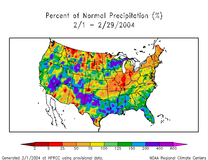
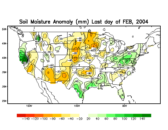
- February was wetter than normal across a significant portion of the western and Great Plains drought areas
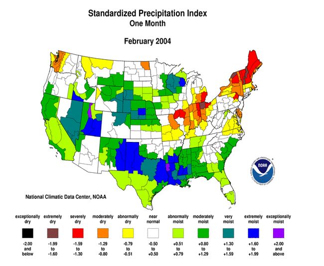
- The month was dry from New England across much of the mid-Atlantic coast and Ohio Valley
- February marked the second consecutive month with below-normal precipitation regionwide across the Northeast
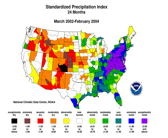
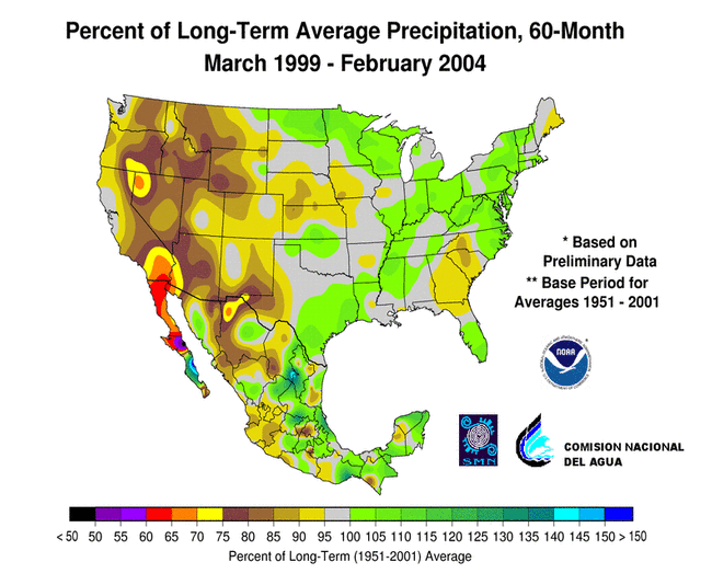
- Long-term moisture deficits (last 9 to 24 to 60 months) persisted across parts of the Upper Midwest to southern Plains, and most of the West
Please Note: The data presented in this drought report are preliminary. Ranks, anomalies, and percent areas may change as more complete data are received and processed.
National Overview
On the national scale,
- severe to extreme drought affected about 10 percent of the contiguous United States as of the end of February 2004, a decrease of about 9 percent compared to last month
- about 24 percent of the contiguous U.S. fell in the moderate to extreme drought categories (based on the Palmer Drought Index) at the end of February
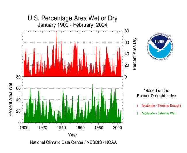
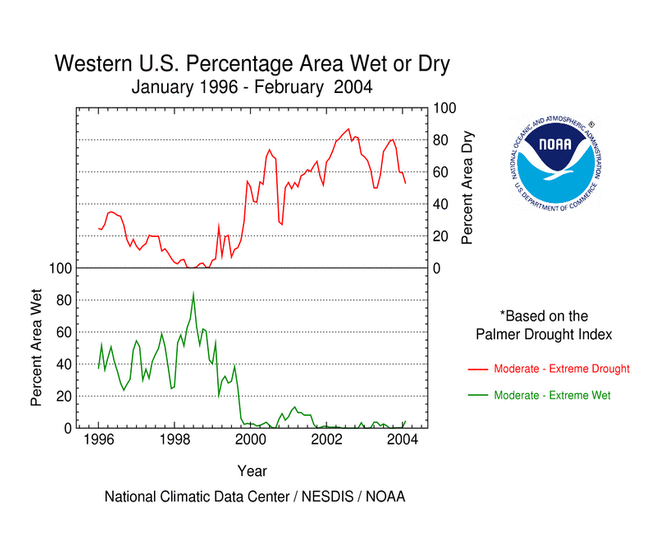
- on a broad scale, the last two decades were characterized by unusual wetness with short periods of extensive droughts, whereas the 1930s and 1950s were characterized by prolonged periods of extensive droughts with little wetness
- about 5 percent of the contiguous U.S. fell in the severely to extremely wet categories at the end of February
- a file containing the national monthly percent area severely dry and wet from 1900 to present is available
- historical temperature, precipitation, and Palmer drought data from 1895 to present for climate divisions, states, and regions in the contiguous U.S. are available at the Climate Division: Temperature-Precipitation-Drought Data page in files having names that start with "drd964x" and ending with "txt" (without the quotes).
Regional Overview
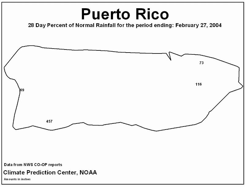
February was drier than normal across much of the U.S. from the Northeast to the mid-Atlantic states westward to the Ohio Valley. The month was also dry along coastal Washington state and in parts of the northern Plains and northern Rockies. Interior Alaska was predominantly dry, while the rainfall pattern in Hawaii was mixed. The pattern in Puerto Rico was mixed during the last 4 weeks to 8 weeks, with generally drier than normal conditions in the north and east.
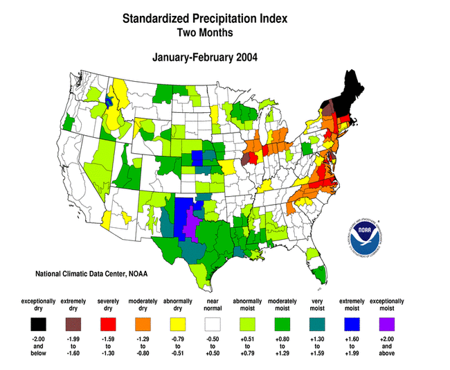
February marked the second consecutive month with below-normal precipitation across New England, where several states (Maine, New Hampshire, and Vermont) had the second driest January-February in the 1895-present record. Above-normal precipitation brought a reprieve to much of the Southeast, where conditions had been generally drier than normal for the preceding four months.
Abundant rain and snow fell across much of the drought areas of the West and Great Plains this month. While drought conditions improved in some areas, long-term moisture deficits (last 9 to 24 to 60 months) persisted.
Some regional highlights:
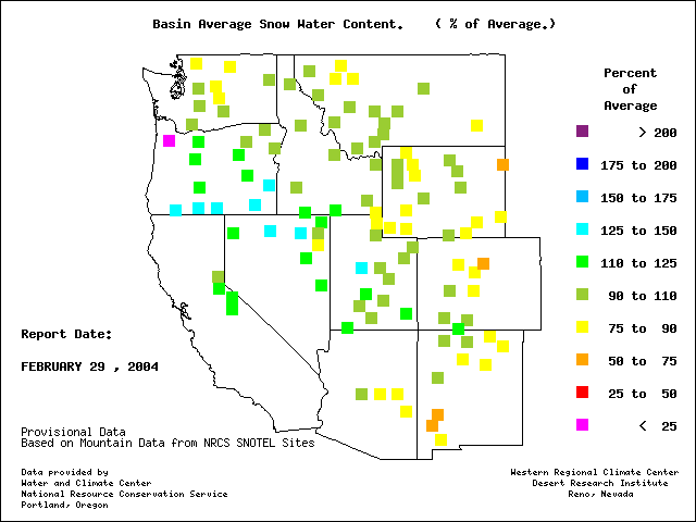
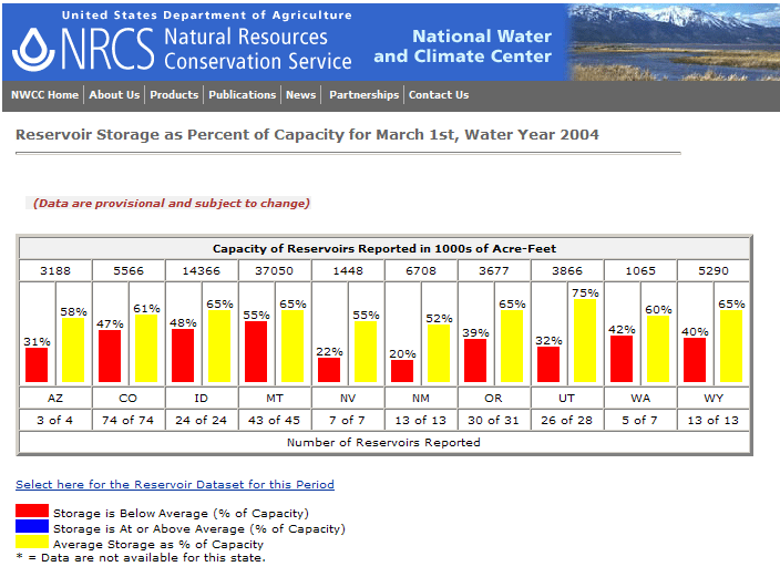
- A series of winter storms brought an average to above-average snowpack and water year-to-date precipitation to much of the West, especially the coastal and interior basin areas. But snowpack across much of the Rocky Mountains, and especially the Southwest, remained below seasonal norms. The effects of the long-term drought include:
- soil moisture conditions remained dry in many areas
- reservoirs in most of the western states were still low or depleted
- average streamflow remained well below normal levels in many areas
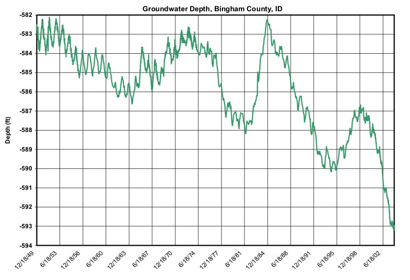
- groundwater levels were at record low levels in southeast Idaho (as represented by the Bingham County station) and south central Idaho (according to media reports [Idaho Statesman, 3/10], record low well levels last summer threaten to shut down groundwater users north of the Snake River near Twin Falls)
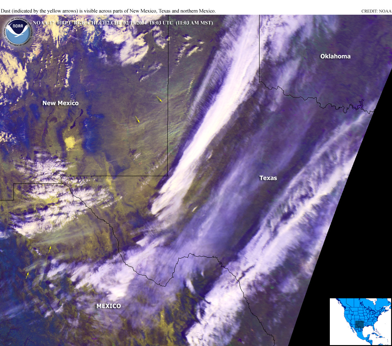
- On February 19, just days before a major winter storm brought copious rain and snow to western Texas and adjoining New Mexico, strong winds created thick blinding dust storms in the area which caused a series of traffic accidents that reportedly killed 2 people and injured dozens of others. The dust storms were characterized by strong winds -- near 60 miles per hour -- and low visibility, in places (according to news reports) down to 50 feet to half a mile. The blowing dust was detectable via satellite (NOAA/NESDIS Satellite Services Division).
- In Oregon, the county commissioners have declared a drought for Klamath County.
- As reported in the February 19 Casper Star-Tribune, the Wyoming State Engineer's Office has placed restrictions on the use of water from the North Platte River in an effort to help fill Pathfinder and Guernsey reservoirs in southeast Wyoming.
- The percent area of the western U.S. (Rockies westward) experiencing moderate to extreme drought (as defined by the Palmer Drought Index) decreased during February to about 53%. While this is not near record historical levels, it is still comparable to the major droughts of the 20th Century.
- Persistently below-normal precipitation this winter in Alaska has resulted in a subnormal snowpack across much of the state.