 larger image |
National Drought Overview
| As the year began, moderate to extreme drought* covered one-third of the contiguous United States including much of the West and parts of the central and northern Plains to central Great Lakes. Precipitation in many of the drought areas during the subsequent five months resulted in a decrease of the drought area to about 20 percent by June. The combination of generally warmer- and drier-than-average conditions during the following four months led to an increase in the areal coverage to about 41 percent by October. Generally wetter conditions near the end of the year caused a decrease in the drought area to about 31 percent by the end of December. The percent area of the nation in severe to extreme drought followed a similar pattern throughout the year. |
 |
*This drought statistic is based on the Palmer Drought Index, a widely used measure of drought. The Palmer Drought Index uses numerical values derived from weather and climate data to classify moisture conditions throughout the contiguous United States and includes drought categories on a scale from mild to moderate, severe and extreme. The most extensive national drought coverage during the past 100 years (the period of instrumental record) occurred in July 1934 when 80 percent of the contiguous U.S. was in moderate to extreme drought. Although the current drought and others of the 20th century have been widespread and of lengthy duration, tree ring records indicate that the severity of these droughts was likely surpassed by other droughts including that of the 1570s and 1580s over much of the western U.S. and northern Mexico. |
Regional Drought Overview
| The 2003 national drought affected different regions at different times. The year started with a very dry January in the southwestern and southeastern quarters of the nation. Persistently below-average precipitation in the Upper Mississippi Valley and Great Lakes region during the winter resulted in record (Minnesota) or near-record dry November-March ranks for several states. The West region (California-Nevada) experienced subnormal precipitation during the last half (January-March) of their wet season. |  |
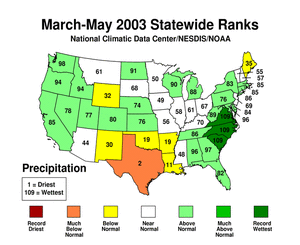
| Spring was very dry in the southern Plains, with Texas experiencing the driest March-May in the 109-year record during 2003. |
 |
 |
| Unusually dry and warm conditions during the early summer to early autumn months exacerbated drought in the West and central to northern Plains, resulting in the expansion of the national drought area. The Northwest, Southwest, West North Central, and East North Central regions were especially affected. Several states had precipitation ranks in the top ten driest category for May-September, July-October, and August-October. The drought severely impacted pasture and rangeland, streamflow, and soil moisture in several states. A meager winter snowpack and below-average precipitation across much of the western mountains failed to recharge depleted reservoirs and set the stage for an active wildfire season in the West. But for the year, the number of acres burned across the US was near average. |  |
 |
 |
| At year's end, moderate to extreme drought covered approximately 56 percent of the western states from the Rockies to the Pacific coast. During the peak of the 2003 drought, about 80 percent of this region was affected, which rivals the extensive drought area of the worst 20th century droughts. A major late winter storm dumped near-record snowfall on parts of the central Rockies, bringing snow water content to near or slightly above average, and a series of winter storms late in the year brought above-average rain and snow to parts of the West. Short-term relief resulted from these systems, but the moisture deficits in the West were so great from three to five years of drought that many more months of above-average precipitation are needed to end the drought in much of the region. |
 |
 |
Pre-instrumental Drought Perspective
Tree ring records
provide a useful paleoclimatic index that extends our historical
perspective of droughts centuries beyond the approximately 100-year
instrumental record. Several paleoclimatic studies have shown that
droughts as severe or worse, both in magnitude and duration, than
the major 20th century droughts have occurred in the U.S. during
the last thousand years. The following paleodrought reports have
been prepared by the NOAA/NCDC Paleoclimatology and Climate
Monitoring branchs during 2003:
|
 NOAA's National Centers for Environmental Information