U.S. Drought Highlights:

- On the national scale, severe to extreme drought affected about 26 percent of the contiguous United States as of the end of September 2003
- moderate to extreme drought affected about 37 percent of the contiguous U.S.
- Short-term conditions were dry across much of the West and parts of the Great Plains, Great Lakes, and Southeast
- Some areas from the Upper Mississippi Valley to the Far West have experienced significant dryness for the last three months
- Long-term moisture deficits (last 12 to 24 months) persisted across parts of the Great Lakes to central and northern Plains, Maine, and most of the West
Please Note: The data presented in this drought report are preliminary. Ranks, anomalies, and percent areas may change as more complete data are received and processed.
National Overview
On the national scale,
- severe to extreme drought affected about 26 percent of the contiguous United States as of the end of September 2003, about the same as last month
- about 37 percent of the contiguous U.S. fell in the moderate to extreme drought categories (based on the Palmer Drought Index) at the end of September
- on a broad scale, the last two decades were characterized by unusual wetness with short periods of extensive droughts, whereas the 1930s and 1950s were characterized by prolonged periods of extensive droughts with little wetness (see graph below right)
- about 16 percent of the contiguous U.S. fell in the severely to extremely wet categories at the end of September
- a file containing the national monthly percent area severely dry and wet from 1900 to present is available
- historical temperature, precipitation, and Palmer drought data from 1895 to present for climate divisions, states, and regions in the contiguous U.S. are available at the Climate Division: Temperature-Precipitation-Drought Data page in files having names that start with "drd964x" and ending with "txt" (without the quotes).
Regional Overview
Near to above-normal rain fell across parts of the western drought areas during September, but many other areas remained dry. The month was dry across parts of the Great Plains, Great Lakes, and Southeast. The primary stations in Hawaii and much of Alaska were drier than normal during September. The precipitation pattern for the stations in Puerto Rico for the last 4 weeks to 8 weeks was generally drier than normal.

The dryness of September was a contiuation of dry conditions from August across much of the western Great Lakes to Upper Mississippi Valley, from July across parts of the northern Plains, northern Rockies, and Southwest, and June across much of the Pacific Northwest. Even longer-term moisture deficits (last 12 to 24 months) persisted across parts of the Great Lakes to central and northern Plains, Maine, and most of the West.
Some regional highlights:
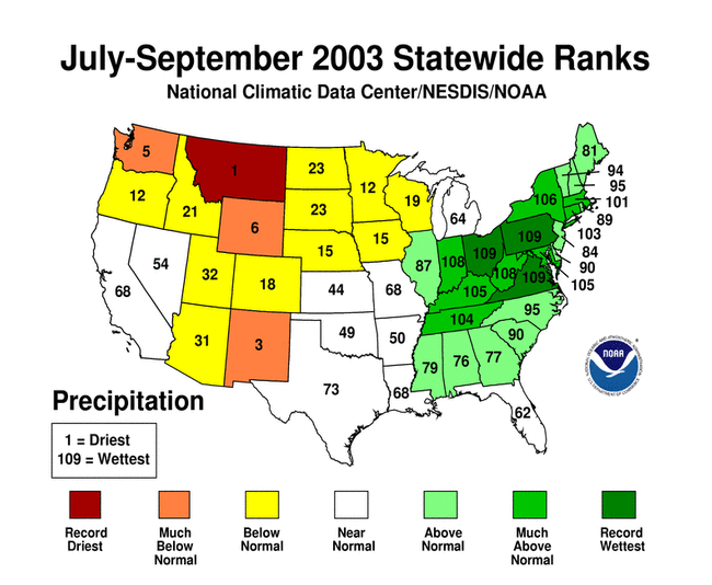
- Montana had its driest July-September, Washington its driest June-September and May-September and fifth driest July-September, New Mexico its second driest April-September and third driest July-September, Oregon its second driest June-September, and Wyoming its seventh driest April-September and sixth driest July-September, in 2003, based on statewide records going back to 1895
- according to October 5 reports from the USDA,
- 60% or more of the topsoils were classified in "poor" or "very poor" ("short" or "very short") condition for all but one of the reporting states from the Rockies westward
- 50% or more of the topsoils were classified in "poor" or "very poor" ("short" or "very short") condition for Georgia, Texas, and the states from the western Great Lakes to central and northern Plains
- end-of-September reservoir storage for all of the reporting western states averaged below the long-term mean percent of capacity for this time of year
- the percent area of the western U.S. (Rockies westward) experiencing moderate to severe drought (as defined by the Palmer Drought Index) increased during September to about 76%, which is near record historical levels