U.S. Drought Highlights:

- On the national scale, severe to extreme drought affected about 32 percent of the contiguous United States as of the end of September 2002
- moderate to extreme drought affected about 45 percent of the contiguous U.S.
- Much of the western U.S. continued to suffer from drought, both short-term and long-term
- Conditions were dry over parts of the adjoining Great Plains
- Short-term conditions improved across parts of the eastern U.S., but severe long-term moisture deficits continued along much of the eastern seaboard
Please Note: The data presented in this drought report are preliminary. Ranks, anomalies, and percent areas may change as more complete data are received and processed.
National Overview
On the national scale,
- about 45 percent of the contiguous U.S. fell in the moderate to extreme drought categories (based on the Palmer Drought Index) at the end of September;
- severe drought affected about 32 percent of the contiguous United States as of the end of September 2002;
- the coverage of the current (November 1999-present) national-scale drought first peaked in August 2000 at about 36% of the contiguous U.S., which was as extensive as the major droughts of the last 40 years, but not as large as the "dust bowl" droughts of the 1930s and 1950s;
- the total drought area decreased to about 10 percent by November 2000, but has shown a general increasing trend for much of the period since then, reaching in July 2002 the peak it had first reached in August 2000 (see graph below left);
- on a broad scale, the last two decades were characterized by unusual wetness with short periods of extensive droughts, whereas the 1930s and 1950s were characterized by prolonged periods of extensive droughts with little wetness (see graph below right);
- although various parts of the U.S. have experienced unusually wet conditions during the last 35 months, little change occurred in the aggregate national wetness picture during much of this period;
- the percentage of the nation severely wet has remained below about eleven percent during this period, reaching about 5 percent by the end of September 2002 (see graph below left);
- a file containing the national monthly percent area severely dry and wet from 1900 to present is available;
- historical temperature, precipitation, and Palmer drought data from 1895 to present for climate divisions, states, and regions in the contiguous U.S. are available at the Climate Division: Temperature-Precipitation-Drought Data page in files having names that start with "drd964x" and ending with "txt" (without the quotes).
Regional Overview
The remnants of Hurricane Isidore dumped heavy rains across much of the Gulf Coast to Ohio Valley during September, bringing short-term relief to many of the drought areas from the southern Appalachians to Ohio Valley. An upper-level weather system brought above-normal precipitation to the Southwest and frontal rains kept much of the Northeast moist this month. However, long-term conditions continued dry across much of the West and along the eastern seaboard from northern Florida to parts of Maine. Heavy rains from Tropical Storm Fay brought short-term relief to southern Texas, but long-term moisture deficits in deep south Texas continued in the severe drought category. September was dry from the central Plains to the southern Great Lakes. The primary stations in Hawaii were drier than normal during September, while the departures were mixed in Puerto Rico. The southern stations in Alaska were drier than normal, while the rest of the Alaskan stations were wetter than normal.
These overall conditions are evident in the following indicators:

- the runoff, evaporation, and soil moisture conditions as calculated by the National Weather Service,
- maps showing the percent of normal precipitation for airport stations for the current month and year-to-date,


- the percent of average precipitation map for the hydrologic year just ended (October 1, 2001 - September 30, 2002) for the SNOTEL stations in the western mountains provided by the USDA Water and Climate Center,
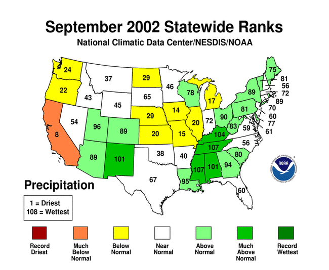
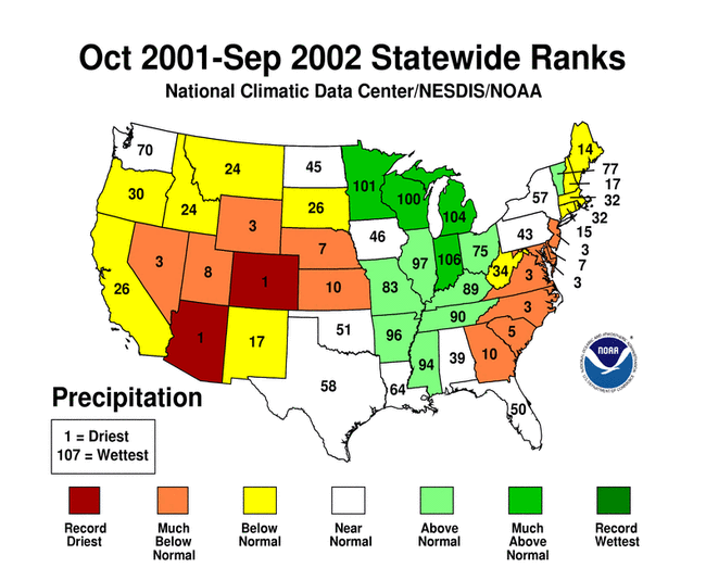
- the statewide precipitation ranks for current month (short-term) and 3-months, 6-months, year-to-date, and 12 months (longer-term),


- the short-term surface wetness anomaly map for November computed by the National Climatic Data Center from the Special Sensor Microwave Imager (SSMI), a polar orbiting satellite with global coverage, and


- the USGS November daily streamflow maps.
Two other drought-related monitoring tools are the Vegetation Health Index and the Keetch-Byram Drought Index:
- NOAA satellite observations of vegetation health from late September revealed stress on vegetation across the southwestern quarter of the U.S., and from the southern Appalachians to mid-Atlantic region.
- The USDA Forest Service uses a satellite-based vegetation health index tool to monitor the risk of wildfires. This Greenness Index for late September revealed above-average stress on vegetation across parts of the West and adjoining Great Plains, as well as parts of the southeastern U.S.
- The Keetch-Byram Drought Index (KBDI) is used by the Wildland Fire Assessment System to monitor the risk of wildfires. The end-of-September KBDI showed dry conditions across much of the Far West and parts of the southern Plains and Southeast. The Forest Service fire danger analysis indicated a high risk of wildfires across parts of the Southwest and High Plains. The fire threat conditions can change rapidly from week to week.
Fire activity was much reduced in September compared to the earlier months of the fire season. During the first ten days of the month, wildfires were scattered throughout much of the western United States. The eastern wildfire season generally begins to get underway at this time. However, rainfall associated with tropical systems has helped to alleviate some drought in the Southeast, with fire risk lessened in these areas.
On September 10, the U.S. Department of Agriculture (USDA) authorized emergency haying and grazing on Conservation Reserve Program (CRP) acres across the nation to provide relief for farmers and ranchers in areas hardest hit by drought and other natural disasters. Previously, emergency haying and grazing on CRP lands had been limited to 18 states (Environment News Service, 9/10).
According to September 22 USDA reports, with 52% of national pastureland in very poor to poor condition, there were:
- 13 states with more than 66% of pastures very poor to poor
- 26 states with at least 50% very poor to poor
Western U.S. Drought
September is near the end of the dry season for the West and Northwest regions, so below normal summer precipitation has less of an impact here than in the winter. However, this month is near the end of the wet season for the Southwest region and the northern Rockies. On a regional basis, September 2002 continued a drier than normal run of months in the West and Northwest regions. But a wetter than normal September in the Southwest interrupted that region's dry run.


By the end of September, topsoil moisture conditions were very dry across much of the western, north central, and northeast U.S. According to September 29 USDA reports, 50% or more of the topsoil was short to very short in Oregon (88%), Wyoming (85%), New Mexico (74%), Washington (69%), Idaho (69%), Utah (57%), and Colorado (56%).
A detailed review of drought conditions is available for the following regions and states:
- Pacific Northwest region
- West region
- Southwest region
- Arizona
- California
- Colorado
- Idaho
- Nevada
- Oregon
- Utah
- Washington
- Wyoming
Central U.S. Drought
The September rainfall pattern between the Rocky and Appalachian mountain ranges was mixed along the front range of the Rockies, dry from the Texas panhandle to the southern Great Lakes, and wet along and east of the Lower Mississippi and Ohio Valleys. Severe long-term drought continued across parts of the central and northern Plains and the Trans-Pecos and deep south Texas, with moderate long-term drought developing in parts of the southern Great Lakes. On a regional basis, September brought a return to dry conditions for the West North Central and East North Central regions, while the month averaged near normal for the South and Central regions.


By the end of September, topsoil moisture conditions were very dry across much of the northern and central portions of the U.S. According to September 29 USDA reports, 50% or more of the topsoil was short to very short in Missouri (76%), Kansas (75%), Nebraska (71%), Michigan (71%), West Virginia (64%), South Dakota (60%), Ohio (59%), Montana (54%), Illinois (51%), and North Dakota (50%).
A detailed discussion of drought conditions is available for the following regions and states:
- West North Central region
- East North Central region
- Central region
- Illinois
- Kansas
- Missouri
- Nebraska
Eastern U.S. Drought
September rains brought short-term drought relief to much of the eastern U.S. On a regional basis, both the Northeast and Southeast regions averaged above normal for the month. However, short-term drought persisted along parts of the coastal mid-Atlantic, and long-term deficits remained severe.
By the end of September, topsoil moisture conditions were very dry in areas from the mid-Atlantic to Maine. According to September 29 USDA reports, 50% or more of the topsoil was short to very short in Pennsylvania (65%), Maine (65%), Maryland (59%), and Connecticut (50%).
A detailed discussion of drought conditions is available for the following regions and states: