National Overview

On the national scale,
  • severe drought affected about 17 percent of the contiguous United States as of the end of March 2002;
  • the coverage of the current (November 1999-present) drought peaked in August 2000 at about 36% of the contiguous U.S., which was as extensive as the major droughts of the last 40 years, but not as large as the "dust bowl" droughts of the 1930's and 1950's;
  • the total drought area decreased to about 10 percent by November 2000, but has shown a general increasing trend for much of the period since then (see graph below left);
  • on a broad scale, the last two decades were characterized by unusual wetness with short periods of extensive droughts, whereas the 1930's and 1950's were characterized by prolonged periods of extensive droughts with little wetness (see graph below right);
  • although various parts of the U.S. have experienced unusually wet conditions during the last 29 months, little change occurred in the aggregate national wetness picture during much of this period;
  • the percentage of the nation severely wet has held steady at about three to eleven percent during this period, only recently falling below one percent (see graph below left);
  • a file containing the national monthly percent area severely dry and wet from 1900 to present is available;
  • historical temperature, precipitation, and Palmer drought data from 1895 to present for climate divisions, states, and regions in the contiguous U.S. are available at the Climate Division: Temperature-Precipitation-Drought Data page in files having names that start with "drd964x" and ending with "txt" (without the quotes).
Click here for graphic showing U.S. Drought and Wet Spell Area, 1996-present
larger image
Click here for graphic showing U.S. Drought and Wet Spell Area, 1900-present
larger image

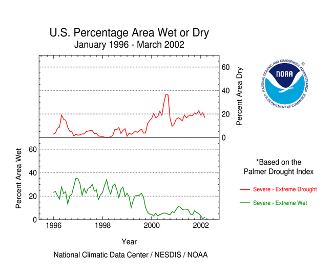
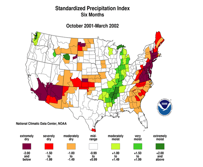
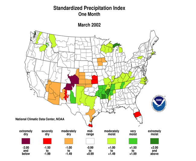
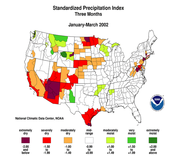
Although some areas of the U.S. had above normal precipitation, many areas were very dry. Integrated across the nation, March 2002 precipitation averaged near normal. Twelve of the last 31 months have averaged well below the normal, while only three averaged well above normal (see graph to right). National 2001-2002 precipitation ranks: Click here for graphic showing U.S. Precipitation Departure and Normals, January 1998-present
larger image

Regional Overview

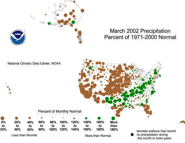
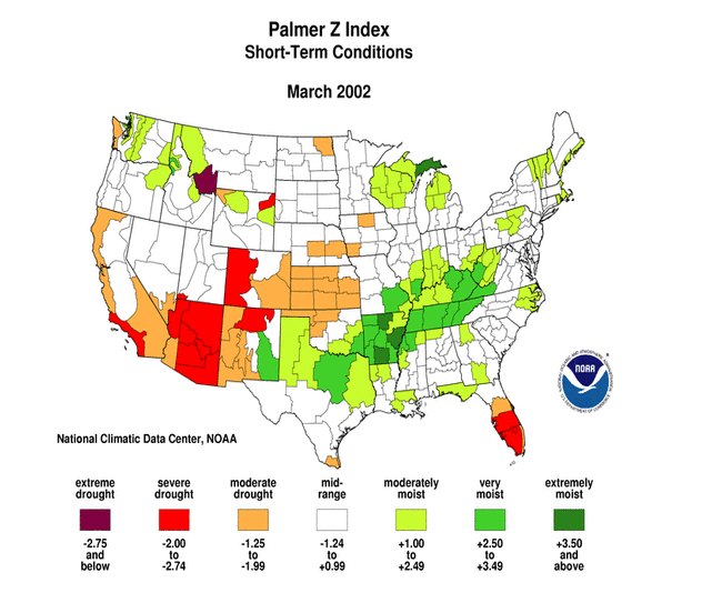
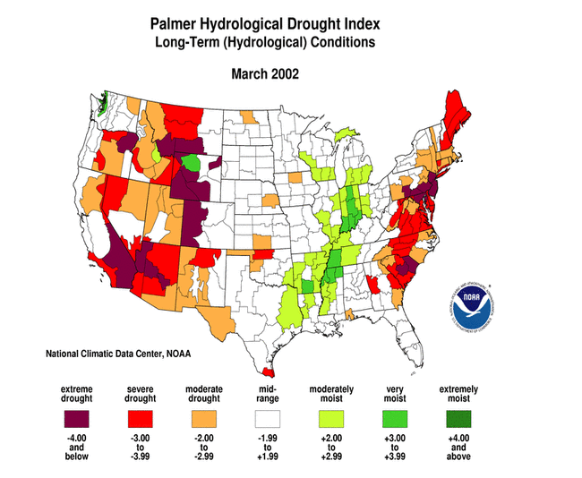
Across the western U.S., beneficial precipitation during March continued a gradual amelioration in drought conditions in the Pacific Northwest and parts of the northern Rockies while dryness intensified across much of California to Colorado and New Mexico and the Texas Trans-Pecos region. Beneficial precipitation also brought short-term relief to parts of the eastern U.S. this month, but long-term drought continued its stranglehold across the eastern seaboard. Dry conditions during March in parts of the central and southern Plains continued a pattern of longer-term dryness in some areas. March was generally drier than normal across most of Alaska and at the primary stations in the southern islands of Hawaii. Snowpack at the end of March was below average across much of northern, western, and interior Alaska. This overall pattern is evident in the following indicators:

Two other drought-related monitoring tools are the Vegetation Health Index and the Keetch-Byram Drought Index:

  • NOAA satellite observations of vegetation health from late March reveal stress on vegetation in parts of the southern and central Plains and southwestern U.S.
  • The Keetch-Byram Drought Index (KBDI) is used by the Wildland Fire Assessment System to monitor the risk of wildfires. The late March KBDI showed dry conditions from the Desert Southwest to parts of the northern Rockies, and across the Florida peninsula. The Forest Service fire danger analysis indicated a high risk of wildfires from the Southwest to the Great Lakes, and across part of northern Florida.


Western U.S. Drought

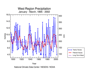
March continued the precipitation pattern of recent months, with Pacific storms bringing limited drought relief to the northern portions of the western U.S. while the southern portions continued dry. On a regional basis, the Pacific Northwest had the 39th wettest March in the last 108 years, while March 2002 ranked 31st driest in the West region and 19th driest in the Southwest. Reservoir levels across the West were still generally below-average, reflecting dry conditions in the very long-term (24 months or longer).

The rainy season (October-March) for the West region started out wet, but the last three months have been drier than normal regionwide (see graph below left). January-March 2002 ranked as the seventh driest January-March on record for the region (see graph below right). The last 12 months ranked as the 24th driest April-March on record for the region.

Click here for graphic showing West Region Precipitation Anomalies, January 1998 - present
larger image
Click here for graphic showing West Region Precipitation, January-March, 1895-2002
larger image

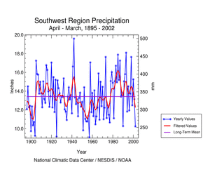
The Southwest region has experienced persistently dry conditions for much of the last ten months (see graph below left). Mountain snowpack was considerably below average, with snow water equivalent ranging from 25 to 50 percent of average, or less, in many areas. January-March 2002 ranked as the third driest such year-to-date on record regionwide, with other notable ranks (see table below right) including the sixth driest April-March (see graph below right) and second driest September-March.

Click here for graphic showing Southwest Region Precipitation Anomalies, January 1998 - present
larger image
Click here for graphic showing Southwest Region Precipitation, April-March, 1895-2002
larger image

Drought impacts in the western U.S., as compiled by the National Weather Service / Climate Prediction Center:
  • Northern Rockies -- increased risk of above average fire season
  • Four Corners & Southwest –- fire season already active; enhanced fire risk should continue
  • Montana and Wyoming -– 3 to 4 years of drought; winter wheat crop in poor condition
  • New Mexico -- diminishing reservoir levels
The early start to the fire season in New Mexico and Arizona has been reported by the Associated Press and the Arizona Republic, and there is concern over the rising fire danger in Colorado (Denver Post).

USA Today reported that Utah "faced its worst drought since the 1930s".

The Associated Press reported that U.S. Agriculture Secretary Ann Veneman declared Montana a drought disaster area near the end of March.

Precipitation Ranks for the
Southwest Region, 2001-2002
Period Rank
Mar 19th driest
Feb-Mar 3rd driest
Jan-Mar 3rd driest
Dec-Mar 7th driest
Nov-Mar 11th driest
Oct-Mar 5th driest
Sep-Mar 2nd driest
Aug-Mar 6th driest
Jul-Mar 5th driest
Jun-Mar 4th driest
May-Mar 4th driest
Apr-Mar 6th driest


Central U.S. Drought

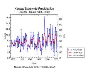
March 2002 was unusually dry across parts of Kansas, Oklahoma, and southern Texas. This month was a continuation of dryness for some of these areas, especially southern Texas, while other parts of the northern and central Plains have experienced dryness on the longer term (see map below left). Kansas had the fourth driest October-March in the last 108 years during 2001-2002 (see graph below right).

Click here for graphic showing Six Month SPI, October 2001 - March 2002
larger image
Click here for graphic showing Kansas Statewide Precipitation, October-March, 1895-2002
larger image

Drought impacts, as compiled by the National Weather Service / Climate Prediction Center:
  • Texas:
    • low soil moisture and irrigation water
    • Rio Grande reservoirs low
    • wet March northern Texas, dry farther south
  • Oklahoma -- livestock sold for lack of wheat pasture
  • Kansas -- wheat is drought-stressed


Eastern U.S. Drought
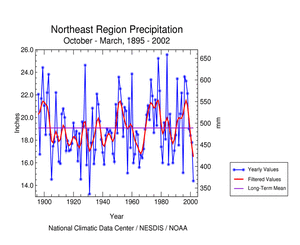
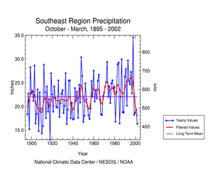
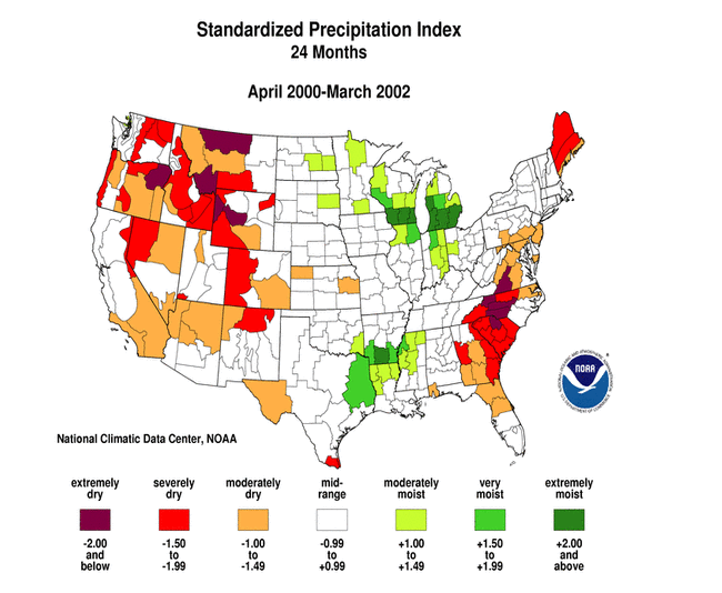
March was wet across portions of the Northeast and Southeast regions, with dry conditions dominating central and southern Florida (see map below left). On a regionwide basis, the Northeast had the 36th wettest March and the Southeast the 45th wettest March in the last 108 years. However, long-term drought remained a problem as the last six months were an extremely dry period in some places (see map below right). April 2001-March 2002 was the driest such 12-month period on record for Maine and second driest for New Hampshire, New Jersey, and South Carolina.

Click here for map showing March 2002 Palmer Z Index
larger image
Click here for map showing Six-Month SPI, October 2001-March 2002
larger image

Drought impacts in the northeastern U.S., as compiled by the National Weather Service / Climate Prediction Center:
  • local water use restrictions were in effect in some localities
  • shallow wells dry in New England
  • increased wildfire potential in eastern Maine
  • New Jersey -- low groundwater; reservoir stores less than 50% of normal
  • system-wide drought emergency declared in New York City; reservoir stores less than 60% of normal
  • Coastal Plain -- near-record low streamflows
  • beneficial near- to above-normal March rains boosted streamflows and topsoil moisture
Other impacts:
  • According to The New York Times, the drought in Maine is causing water shortages especially affecting those with shallow rural wells. The USGS noted that the state has been setting record lows for groundwater almost every day for quite a while, with the water level being low for the last two years. Lakes and reservoirs are unusually low.
  • According to the Delaware River Basin Commission, recent precipitation has increased overall reservoir levels, but the levels are still very low. A drought emergency continued in several counties in the New Jersey-Pennsylvania-New York area.
  • NASA satellite pictures of reservoirs in the New York Catskills show how much lower the water level is in the current drought compared to just two years ago.
  • Several hydrologic indicators monitored by the Maryland Department of the Environment are in an emergency status for parts of the state.
Click here for graphic showing Northeast Region Precipitation Anomalies, January 1998-present
larger image

Precipitation Ranks for the
Northeast Region, 2001-2002
Period Rank
Mar 36th wettest
( 73rd driest)
Feb-Mar 38th driest
Jan-Mar 25th driest
Dec-Mar 19th driest
Nov-Mar 5th driest
Oct-Mar 2nd driest
Sep-Mar 5th driest
Aug-Mar 3rd driest
Jul-Mar 3rd driest
Jun-Mar 5th driest
May-Mar 4th driest
Apr-Mar 3rd driest

Click here for graph showing Northeast Region Precipitation, October-March, 1895-96 to 2001-02
larger image
Click here for National Weather Service map showing Mid-Atlantic and New England County Drought Disaster Declarations, April 2, 2002
larger image
(map created by National Weather Service)

Drought impacts in the southeastern U.S., as compiled by the National Weather Service / Climate Prediction Center:
  • spring (March-May) fire season starts –- earliest on record
  • Georgia and the Carolinas -- dry wells; low streamflows; local water use restrictions
  • beneficial near- to somewhat above-normal March rains boost streamflows and topsoil moisture

Drought impacts in South Carolina, as reported by the State Climate Office:

  • In early 2002, 63% of all monitored streams reached record low flows.
  • Numerous reports of private ponds and wells going dry.
  • The hydrologic-drought has wreaked havoc on the tourism industry with devastating losses to many lake-related businesses and golf courses.
  • According to the S.C. Forestry Commission, the drought has significantly contributed to the southern pine beetle epidemic. Trees weakened by drought are more susceptible to the tree-killing beetles. Timber losses due to beetles totaled $9.5 million in 1999, $40.7 million in 2000, $76 million in 2001, and $12 million from January-March 2002. There have also been millions lost due to pine tree root disease.
  • The drought has significantly increased wildfire activity. Wildfire occurrence from July 1, 2001, through March 31, 2002, has already exceeded the average number of fires expected in a normal fiscal year.

Click here for graph showing South Carolina PHDI, January 1900 - March 2002

larger image
Click here for graphic showing Southeast Region Precipitation Anomalies, January 1998-present
larger image

Precipitation Ranks for the
Southeast region, 2001-2002
Period Rank
Mar 44th wettest
( 64th driest)
Feb-Mar 28th driest
Jan-Mar 30th driest
Dec-Mar 22nd driest
Nov-Mar 16th driest
Oct-Mar 7th driest
Sep-Mar 18th driest
Aug-Mar 11th driest
Jul-Mar 11th driest
Jun-Mar 23rd driest
May-Mar 27th driest
Apr-Mar 15th driest

Click here for graph showing Southeast Region Precipitation, October-March, 1895-96 to 2001-02

larger image

Additional Contacts:

Damage due to the drought has been summarized by NOAA and the Office of Global Programs in the Climatological Impacts section of the Climate Information Project. Crop impact information can be found at the USDA NASS (National Agricultural Statistics Service) and Weekly Weather and Crop Bulletin pages. Drought statements by local National Weather Service Offices can be found at the NWS Hydrologic Information Center. Drought threat assessments and other information can be found at NOAA's Drought Information Center. Additional drought information can be found at the National Drought Mitigation Center, the USDA's National Agricultural Library, the interim National Drought Council, and the NOAA Paleoclimatology Program. The following states have set up web pages detailing current drought conditions and/or their plans to handle drought emergencies:
Colorado - Delaware - Delaware River Basin (DE-NJ-NY-PA) - Florida Panhandle - Georgia - Hawaii - Idaho - Kentucky - Maine - Maryland - Missouri - Montana-1 - Montana-2 - Nebraska - New Jersey-1 - New Jersey-2 - New Jersey-3 - New Mexico - North Carolina - Oklahoma-1 - Oklahoma-2 - Oklahoma-3 - Oregon-1 - Oregon-2 - Pennsylvania-1 - Pennsylvania-2 - South Carolina - Texas - Vermont - Virginia - Washington - Wyoming

For additional information on current and past wildfire seasons please see the National Interagency Fire Center web site or the U.S. Forest Service Fire and Aviation web site.

NCDC's Drought Recovery Page shows the precipitation required to end or ameliorate droughts and the probability of receiving the required precipitation.

Additional climate monitoring graphics can be found at the Climate Prediction Center's monitoring pages:

Drought conditions on the Canadian prairies can be found at the Agriculture and Agri-Food Canada Drought Watch page.


Citing This Report

NOAA National Centers for Environmental Information, Monthly Drought Report for March 2002, published online April 2002, retrieved on April 18, 2024 from https://www.ncei.noaa.gov/access/monitoring/monthly-report/drought/200203.