National Overview

On the national scale,
  • severe drought affected about 18 percent of the contiguous United States as of the end of January 2002;
  • the coverage of the current (November 1999-present) drought peaked in August 2000 at about 36% of the contiguous U.S., which was as extensive as the major droughts of the last 40 years, but not as large as the "dust bowl" droughts of the 1930's and 1950's;
  • the total drought area decreased to about 10 percent by November 2000, but has shown a general increasing trend for much of the period since then, with a slight drop recently (see graph below left);
  • on a broad scale, the last two decades were characterized by unusual wetness with short periods of extensive droughts, whereas the 1930's and 1950's were characterized by prolonged periods of extensive droughts with little wetness (see graph below right);
  • although different parts of the U.S. have experienced unusually wet conditions during the last 28 months, there continues to be little change in the overall national wetness picture;
  • the percentage of the nation severely wet has held steady at about three to eleven percent during this period (see graph below left);
  • a file containing the national monthly percent area severely dry and wet from 1900 to present is available;
  • historical temperature, precipitation, and Palmer drought data from 1895 to present for climate divisions, states, and regions in the contiguous U.S. are available at the Climate Division: Temperature-Precipitation-Drought Data page.
U.S. Drought and Wet Spell Area, 1996-present
larger image
U.S. Drought and Wet Spell Area, 1900-present
larger image

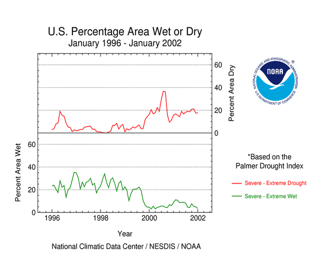
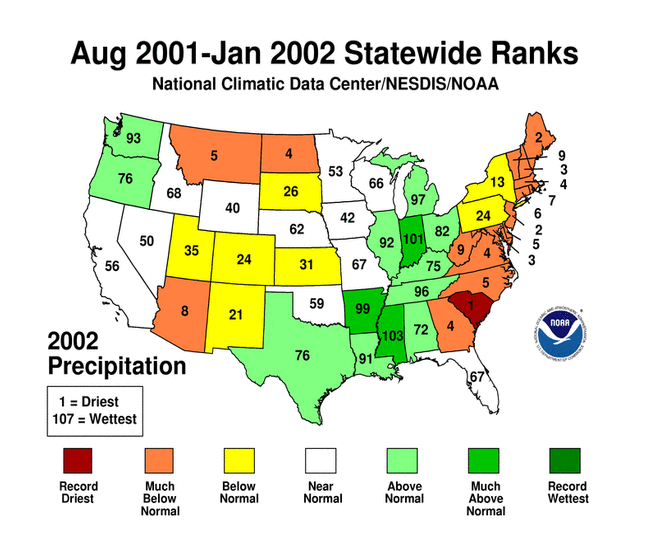
Although some areas of the U.S. had well above normal precipitation, many areas were very dry. January averaged near normal when precipitation is integrated across the nation. Eleven of the last 30 months have averaged well below the normal, while only three averaged well above normal (see graph to right). National 2001-2002 precipitation ranks: U.S. Precipitation Departure and Normals, January 1998-January 2002
larger image

Regional Overview

The beneficial rain and snow in the western U.S. during October through December abated slightly during January. Short-term drought conditions were improved across much of the Pacific Northwest, however long-term deficits remained, especially east of the Cascades. 
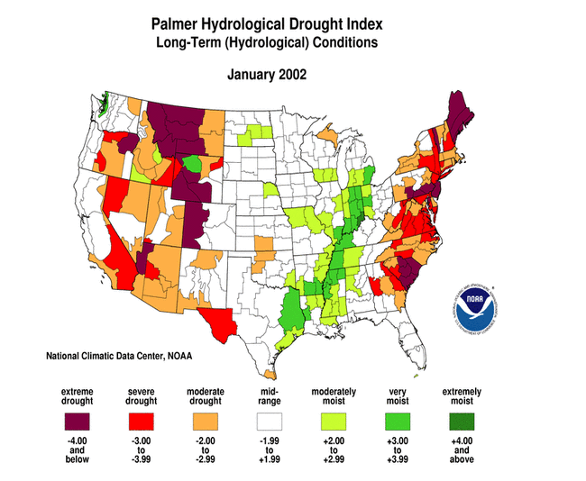
Drought continued its stranglehold across much of the Rockies, the eastern seaboard, and parts of the southern Plains. Conditions deteriorated during January in the Southwest. 
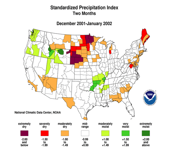
The northern Plains and western Great Lakes were dry during January, with two-month (December-January) deficits stretching from northern Minnesota to western Nebraska. Parts of southeast interior Alaska had a dry January, while mountain snowpack across much of the state was below average. January rains in Hawaii helped alleviate dryness in the islands. This overall pattern is evident in the following indicators:

Two other drought-related monitoring tools are the Vegetation Health Index and the Keetch-Byram Drought Index:

  • NOAA satellite observations of vegetation health from early February reveal borderline stress on vegetation in parts of the southwestern U.S., including western Texas. The VHI product becomes less useful as vegetation goes dormant during the winter.
  • The Keetch-Byram Drought Index (KBDI) is used by the Wildland Fire Assessment System to monitor the risk of wildfires. The early February KBDI showed dry conditions in the Southwest and along the southeast coast. The Forest Service fire danger analysis indicated a high risk of wildfires over the desert Southwest.


Western U.S. Drought

January continued a run of wet months for the Pacific Northwest (see graph below right), however the moisture tap was reduced over much of the rest of the western U.S. The end-of-January mountain snowpack illustrated this regional pattern, with above-average snowpack in the Pacific Northwest and below-average snowpack across the rest of the Far West. The severe impact from last year's dry rainy season is reflected in early February 2002 reservoir levels that were generally still below seasonal norms. Highlights:
  • The Pacific Northwest had the 33rd wettest January and 14th wettest October-January on record in 2002, which has helped the region recover from the extremely dry 2000-2001 season (giving February 2001-January 2002 a rank of 46th driest).
  • Even though the winter season started out snowy, concerns that drought conditions may not be over were expressed in the Idaho Statesman newspaper. The paper's editorial noted that the number of river basins with less than 100% of average snowpack showed an increasing trend.
  • Drought emergencies, declared by the state governors, continued in three western states (Washington, Oregon, and Idaho).
Pacific Northwest Region Precipitation Anomalies, January 1998 - January 2002
larger image
West Region Precipitation Anomalies, January 1998 - January 2002
larger image

This year's rainy season started out wet for the West region, but January came in as drier than normal (see graph above). Highlights:

  • 24th driest January
  • 40th wettest November-January
  • Mountain snowpack and snow water equivalent have shown a declining trend during January, with the Sierra Nevada snowpack dropping to near average conditions as of the end of the month.
Southwest Region Precipitation Anomalies, January 1998 - January 2002
larger image

January 2002 marked the eighth consecutive month with near to well below-normal precipitation for the Southwest region (see graph above). Highlights:

The Colorado Drought Task Force met in January, expressing the following concerns:

  • the state is tracking towards its third consecutive year of below average snowpack
  • the agricultural community is starting to get concerned with the dry winter occurring on top of a dry year
  • municipal water supplies are generally in good shape, but those communities that rely on stream flow could be affected.

Wyoming Statewide Palmer Hydrological Drought Index, January 1900 - January 2002
larger image
Wyoming had the 12th driest February-January, statewide, in 2001-2002. The recent drought, which started in March 2000, rapidly intensified to a peak in September 2001 which (based on the Palmer Hydrological Drought Index) rivaled the peak intensities of the 20th Century droughts in the state (see graph to left).

January was dry across western and southern Texas, further exacerbating long-term drought conditions.
  • The Trans Pecos region of western Texas has been experiencing an on-again off-again drought for the last eight years. At its peak in September 2000, this drought was as severe (based on the Palmer Hydrological Drought Index) as the droughts of the 1930's and 1950's (see graph to right).
  • As reported by the National Weather Service, marginal soil moisture conditions and low irrigation water supplies have farmers and ranchers in the Lower Rio Grande Valley very concerned about making a crop in 2002.
Texas Trans Pecos Region Palmer Hydrological Drought Index, January 1900 - January 2002
larger image


Eastern U.S. Drought
In January, there were areas of above-normal precipitation and below-normal precipitation in the east coast states. This resulted in regionwide January precipitation ranks of 33rd driest for the Northeast and 59th driest for the Southeast. However, severe long-term deficits remain. January was drier than normal for portions of the northern Plains and western Great Lakes (the East North Central region).

Northeast Region Precipitation Anomalies, January 1998 - January 2002
larger image
Southeast Region Precipitation Anomalies, January 1998 - January 2002
larger image

January marked the fourth consecutive month with below to much below normal precipitation for the Northeast region, with October-January 2001-02 ranking as the second driest such period in the 108-year record (see graph to right). The dryness of the last three months was associated with unseasonably warm temperatures, with 2001-02 having the second warmest November-January on record.

Drought impacts have been noted in several states, with public water utilities in some communities requesting voluntary conservation and in others imposing mandatory water restrictions. Some highlights:

Northeast Region Precipitation, October-January, 1895-96 to 2001-02
larger image

  • The Maine state Drought Task Force reported that lake and ground water levels were below normal statewide, with power production curtailed at many sites.
  • The National Weather Service reported that, in Vermont, the Lake Champlain level of 93.7 feet was at its lowest level for this time of year in the past 30 years.
  • As reported by the New York Times, "20 of New Jersey's 21 counties are under drought warnings ... drought warnings are also in effect in 21 counties in New York State ... [and NYC mayor Michael] Bloomberg said the city would soon issue its first drought warning since 1995, an indication that its reservoirs may not fill up by June, when they are supposed to."
  • According to the Pennsylvania Department of Environmental Protection, as of the end of January, 62 of the state's 67 counties were in some sort of drought status, from drought watch in the northwest to drought emergency in the southeast.
  • On January 24, the Maryland Department of the Environment announced that the drought status for Central Maryland and the Eastern Shore was upgraded to a “Drought Warning” while Western Maryland remained in a “Drought Watch.”
Precipitation Ranks
for the Northeast Region, 2001-2002

1 = driest, 107 (108 for January) = wettest
Period Rank
Jan 33rd driest
Dec-Jan 15th driest
Nov-Jan 5th driest
Oct-Jan 2nd driest
Sep-Jan 3rd driest
Aug-Jan 2nd driest
Jul-Jan 2nd driest
Jun-Jan 4th driest
May-Jan 6th driest
Apr-Jan 2nd driest
Mar-Jan 9th driest
Feb-Jan 7th driest

Precipitation averaged across the Southeast region during January was near normal, but the dryness of the previous three months resulted in an October-January rank of sixth driest (see graph below left). Even though four of the last twelve months were wetter to much wetter than normal, the February-January rank was still only 29th driest. The drought epicenter in the Southeast continued to be South Carolina (see map below right), with the state having the driest August-January on record.

Southeast Region Precipitation, October-January, 1895-96 to 2001-02
larger image
Palmer Hydrological Drought Index, January 2002
larger image

The East North Central region has had two consecutive months with precipitation averaging below normal (see graph to right), with January 2002 ranking as the 13th driest January in the 108-year record. The dryness was accompanied by unseasonable warmth, with 2001-2002 chalking up a record warm November-January. However, this is the winter dry season, so impacts have been minimal. East North Central Region Precipitation, January 1998-January 2002
larger image

Additional Contacts:

Damage due to the drought has been summarized by NOAA and the Office of Global Programs in the Climatological Impacts section of the Climate Information Project. Crop impact information can be found at the USDA NASS (National Agricultural Statistics Service) and Weekly Weather and Crop Bulletin pages. Drought statements by local National Weather Service Offices can be found at the NWS Hydrologic Information Center. Drought threat assessments and other information can be found at NOAA's Drought Information Center. Additional drought information can be found at the National Drought Mitigation Center, the USDA's National Agricultural Library, the interim National Drought Council, and the NOAA Paleoclimatology Program. The following states have set up web pages detailing current drought conditions and/or their plans to handle drought emergencies:
Colorado - Delaware - Delaware River Basin (DE-NJ-NY-PA) - Florida Panhandle - Georgia - Hawaii - Idaho - Kentucky - Maine - Maryland - Missouri - Montana-1 - Montana-2 - Nebraska - New Jersey - New Mexico - North Carolina - Oklahoma-1 - Oklahoma-2 - Oregon-1 - Oregon-2 - Pennsylvania-1 - Pennsylvania-2 - South Carolina - Texas - Vermont - Washington - Wyoming

For additional information on current and past wildfire seasons please see the National Interagency Fire Center web site or the U.S. Forest Service Fire and Aviation web site.

NCDC's Drought Recovery Page shows the precipitation required to end or ameliorate droughts and the probability of receiving the required precipitation.

Additional climate monitoring graphics can be found at the Climate Prediction Center's monitoring pages:


Citing This Report

NOAA National Centers for Environmental Information, Monthly Drought Report for January 2002, published online February 2002, retrieved on April 19, 2024 from https://www.ncei.noaa.gov/access/monitoring/monthly-report/drought/200201.