U.S. Drought Highlights:
|
Contents Of This Report: |

|

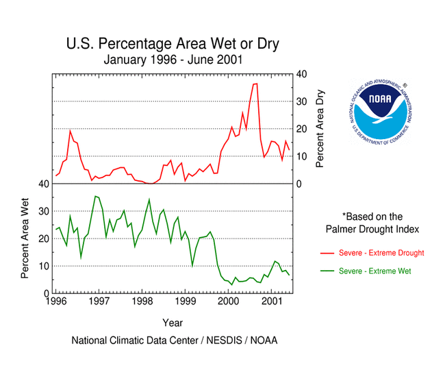
On the national scale,
|
 larger image |
 larger image |
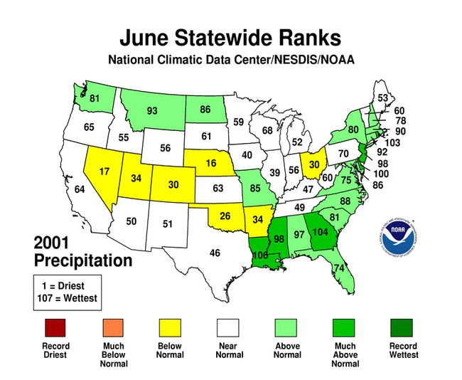
Although some areas of the U.S. had well above normal precipitation, many areas were very dry. June averaged above normal when precipitation is integrated across the nation. Eleven of the last 23 months have averaged well below the normal, while only three averaged well above normal (see graph to right). National 2001 precipitation ranks:
|
 larger image |
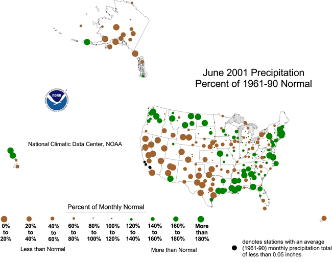
During June 2001, heavy rains from the remnants of Tropical Storm Allison brought relief to parts of the Southeast, however long-term drought persisted across the southern Appalachians, near the confluence of the Ohio and Mississippi rivers, and across most of Florida. Dry conditions continued in the interior Far West and parts of the Northeast, and hot, dry conditions persisted across parts of the southern Plains. This pattern is evident in:
|
|
| The Palmer Z Index shows how monthly moisture conditions depart from normal (short-term drought and wetness). June 2001 was severely dry across the southern portions of the Pacific Northwest into the Great Basin, west Texas, and parts of the central Plains. Heavy rains from the remnants of Tropical Storm Allison brought relief to the Gulf coast states from eastern Texas to nothern Florida, and along the Atlantic coast from Georgia to southern New England. The animated maps to the right show the geographical pattern of the moisture anomalies for the last 12 months. On these maps, the red shading denotes dry conditions while the green shading indicates wet conditions. | 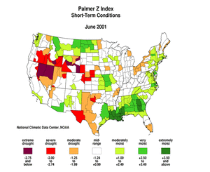 larger animated image |
 larger animated image |
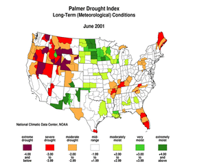
The Palmer Drought Index (PDI) maps show long-term (cumulative) meteorological drought and wet conditions. Long-term meteorological drought persisted across much of the West, Maine, Florida, and parts of western and southern Texas. Recent rains have broken up the drought area and decreased its intensity in much of the Southeast. The animated maps to the left show how the geographical pattern of the long-term (meteorological) moisture conditions has changed over the last 12 months. On these maps, the red shading denotes drought conditions while the green shading indicates wet conditions. |
| The Palmer Hydrological Drought Index maps show hydrological (long-term cumulative) drought and wet conditions, which more accurately reflect groundwater conditions, reservoir levels, etc. The PHDI pattern is similar to the PDI pattern and indicates that hydrological drought persisted through the end of June across much of the West, Maine, Florida, and parts of western and southern Texas. Recent rains have broken up the drought area in the Southeast, with severe drought persisting across the southern Appalachians and near the confluence of the Ohio and Mississippi rivers. The animated maps to the right show the geographical pattern of the long-term (hydrological) moisture anomalies for the last 12 months. On these maps, the red shading denotes dry conditions while the green shading indicates wet conditions. | 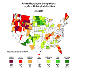 larger animated image |
|
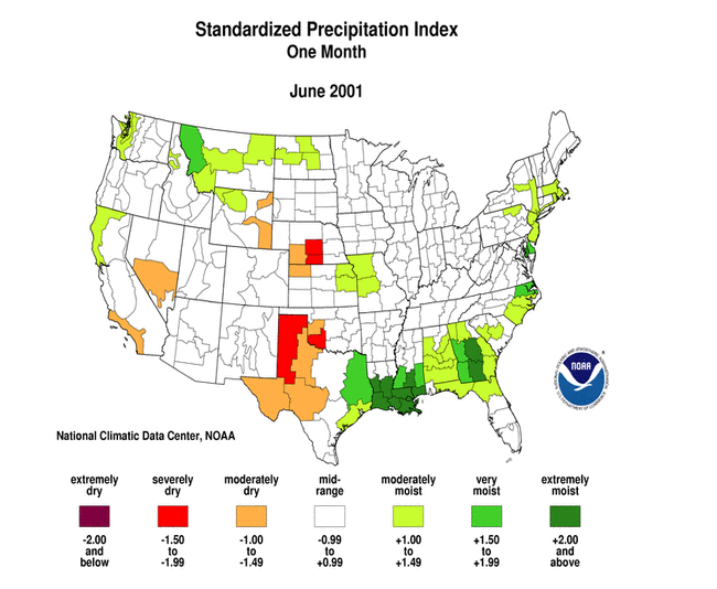
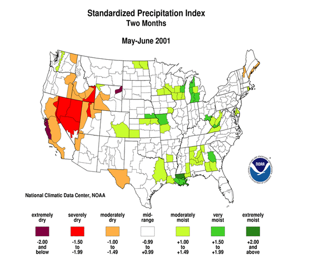
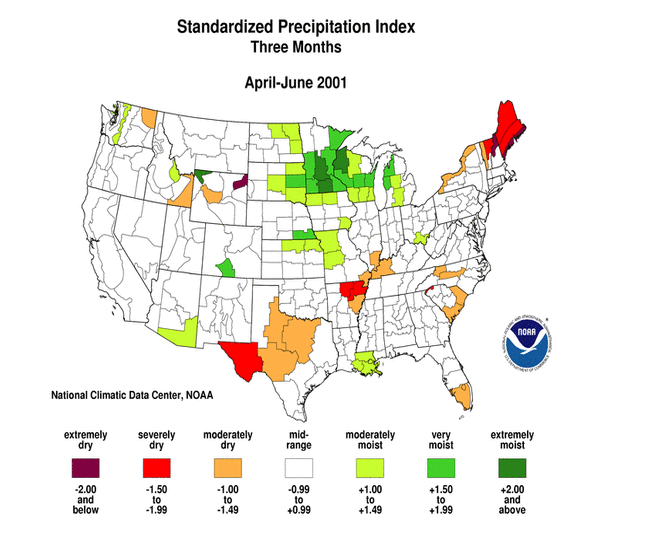
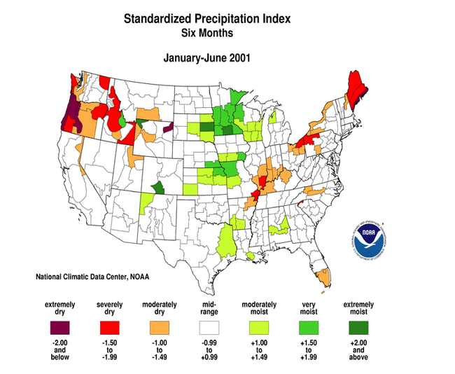
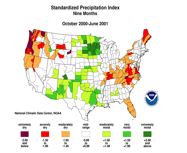
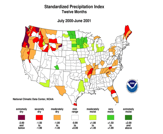
| The Standardized Precipitation Index (SPI) is another way of measuring drought. The index is negative for drought, and positive for wet conditions. The SPI is a probability index that considers only precipitation, while Palmer's indices, shown in the previous maps, are water balance indices that consider water supply (precipitation), demand (evapotranspiration) and loss (runoff).
The seven maps below show the June 2001 spatial patterns of SPI for seven different periods ranging from one month (short-term conditions) to 24 months (long-term conditions). When taken together, they give a combined geographical and temporal picture of the severity of precipitation anomalies. The maps illustrate, for example:
|
 larger image |
 larger image |
 larger image |
 larger image |
 larger image |
 larger image |
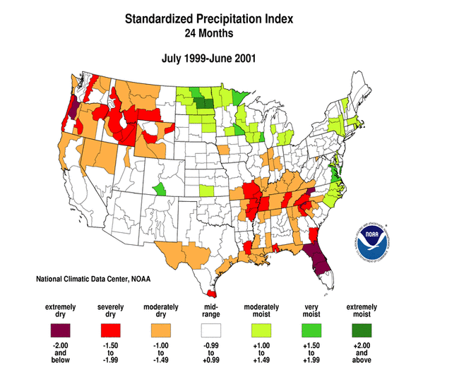 larger image |
|
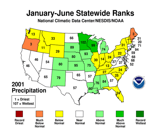
| The following table shows the precipitation ranks for the nine standard U.S. regions for June 2001, the three-month period April-June 2001, and the twelve-month period July 2000-June 2001. A rank of 1 is driest and 107 (106 for July-June) is wettest.
|
| The map to the right shows the departure from normal of the number of days with measurable precipitation for June 2001. The short-term dryness in southwest Alaska, western and central Texas, and the interior Far West shows up on this map as significant below-normal (brown) number of precipitation days. The above-normal precipitation along the northern parts of the Pacific Northwest to the Great Lakes, and along the path of former Tropical Storm Allison in the Southeast, is reflected in a preponderance of above-normal rain days. |  larger image |
|
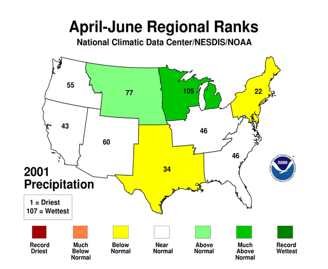
Above-normal rainfall occurred along the Canadian border in June, but it brought limited drought relief to the Pacific Northwest. Ranks for 2001:
|
|
 larger image |
 larger image |
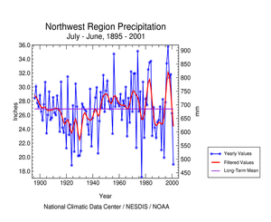
| Below-normal rainfall in the West region resulted in the 43rd driest June regionwide. Conditions were unusually hot and dry in the interior West. Nevada had the 17th driest June and third driest May-June (see graph below right) on record. On a local basis, an observer in Reno, Nevada, reported the driest July-June and fourth warmest June. Parched rangeland and low reservoir, lake, and ground water levels are beginning to impact the water supply for some agricultural and ranching interests. The AP reported that the driest wildland conditions in more than half a century have prompted fire officials to impose outdoor restrictions in parts of the West far earlier than usual. |
 larger image |
 larger image |
 larger image |
The Southwest region had the 27th driest June in 2001. The effects from the lack of rain were compounded by higher than normal evaporation as the region experienced its 16th warmest June in the 107-year record. Water restrictions were being implemented in parts of Utah. |
|
| The remnants of Tropical Storm Allison cut a path across the Southeast region during June. The associated heavy rains effectively broke the region's drought area into three parts centered over Florida, the southern Appalachians, and the confluence of the Ohio and Mississippi rivers (see map below right).
|
 larger image |
 larger image |
| Some of Allison's rains brought limited drought relief to Florida, primarily the northern areas. Statewide precipitation ranks include: |
|
 larger image |
Allison moved across the eastern edge of the South region, dumping copious amounts of rain over eastern Texas to Mississippi. Louisiana experienced the second wettest June on record, with the rain being enough to effectively end the drought there. In spite of the rain, Texas had the 46th driest June statewide. Western and central Texas missed out on the rain (see graph to left). In this region, hot and dry weather (eighth driest June) intensified drought conditions. The AP reported on June 27th that the Rio Grande River, the nation's second-longest river, is now a mere trickle before it gets to the Gulf of Mexico, disappearing about 300 feet short of its destination in a big expanse of sand. |
|
Rainfall over much of the Northeast gave the region its 26th wettest June on record. However, drought persisted in some areas:
|
 larger image |
|
| Damage due to the drought has been summarized by NOAA and the Office of Global Programs in the Climatological Impacts section of the Climate Information Project. Crop impact information can be found at the USDA NASS (National Agricultural Statistics Service) and Weekly Weather and Crop Bulletin pages. Drought statements by local National Weather Service Offices can be found at the NWS Hydrologic Information Center. Drought threat assessments and other information can be found at NOAA's Drought Information Center. Additional drought information can be found at the National Drought Mitigation Center, the USDA's National Agricultural Library, the interim National Drought Council, and the NOAA Paleoclimatology Program. The following states have set up web pages detailing their plans to handle drought emergencies:
New Mexico - North Carolina - Oklahoma - South Carolina - Texas - Washington For additional information on the 2001 wildfire season please see the National Interagency Fire Center web site or the U.S. Forest Service Fire and Aviation web site. NCDC's Drought Recovery Page shows the precipitation required to end or ameliorate droughts and the probability of receiving the required precipitation. Additional climate monitoring graphics can be found at the Climate Prediction Center's monitoring pages: |