U.S. Drought Highlights:

  • On the national scale, severe drought affected about 16 percent of the contiguous United States as of the end of November 2001
  • Beneficial rain and snow fell over parts of the western U.S. during the last two months, but much of the region continued to suffer from long-term moisture deficits
  • Drought continued across much of the eastern seaboard and parts of the southern Plains

Contents Of This Report:


National Overview

On the national scale,
  • severe drought affected about 16 percent of the contiguous United States as of the end of November 2001;
  • the coverage of the current drought peaked in August 2000 at about 36% of the contiguous U.S., which was as extensive as the major droughts of the last 40 years, but not as large as the "dust bowl" droughts of the 1930's and 1950's;
  • the total drought area decreased to about 10 percent by November 2000, but has shown a general increasing trend for much of the period since then (see graph below left);
  • on a broad scale, the last two decades were characterized by unusual wetness with short periods of extensive droughts, whereas the 1930's and 1950's were characterized by prolonged periods of extensive droughts with little wetness (see graph below right);
  • although different parts of the U.S. have experienced unusually wet conditions during the last 26 months, there continues to be little change in the overall national wetness picture;
  • the percentage of the nation severely wet has held steady at about three to eleven percent during this period (see graph below left);
  • a file containing the national monthly percent area severely dry and wet from 1900 to present is available;
  • historical temperature, precipitation, and Palmer drought data from 1895 to present for climate divisions, states, and regions in the contiguous U.S. are available at the Climate Division: Temperature-Precipitation-Drought Data page.
Click here for graphic showing U.S. Drought and Wet Spell Area, 1996-present
larger image
Click here for graphic showing U.S. Drought and Wet Spell Area, 1900-present
larger image

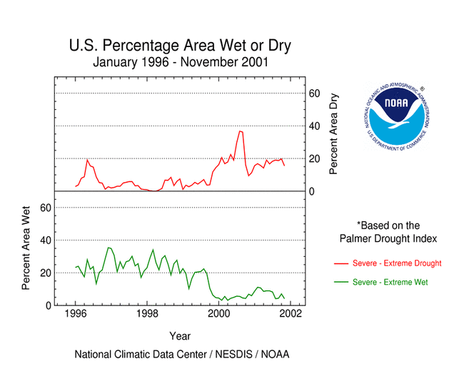
Although some areas of the U.S. had well above normal precipitation, many areas were very dry. November averaged near normal when precipitation is integrated across the nation. Eleven of the last 28 months have averaged well below the normal, while only three averaged well above normal (see graph to right). National 2001 precipitation ranks: Click here for graphic showing U.S. Precipitation Departure and Normals, January 1998-November 2001
larger image

Regional Overview

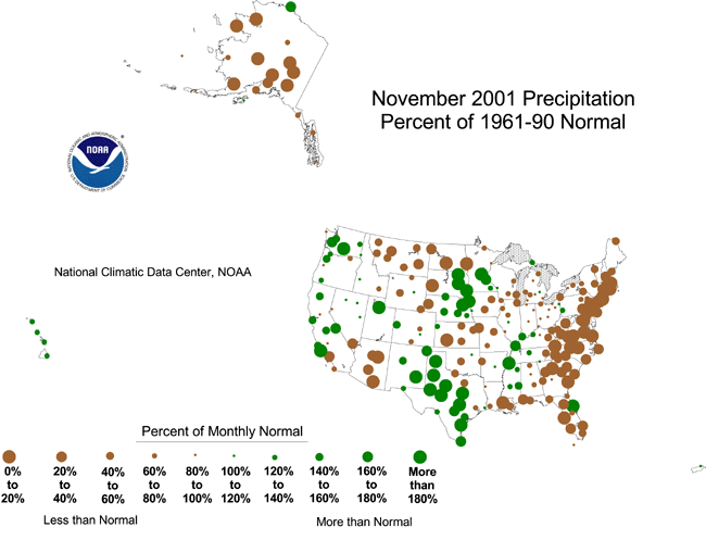
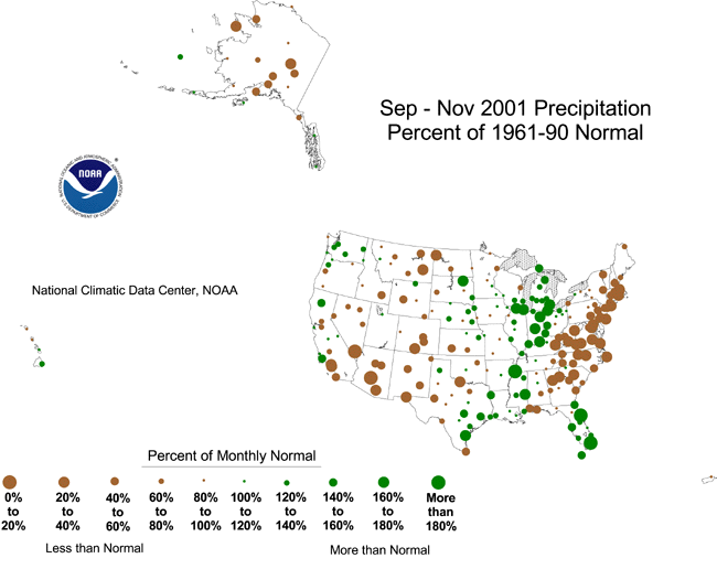
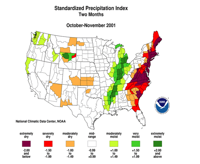
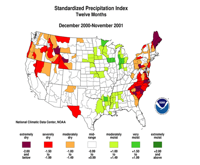
Beneficial rain and snow during October and November brought short-term relief from drought to much of the western U.S., however long-term drought continued to plague much of the region, especially from the interior basin to the Rockies. November was dry across parts of the Southwest, northern Rockies, and northern and central Plains. November marked the second consecutive dry month along the eastern seaboard, intensifying long-term drought conditions. The primary stations in Hawaii were wet during November, but most of the Alaska stations were dry. This overall pattern is evident in the following indicators: Two other drought-related monitoring tools are the Vegetation Health Index and the Keetch-Byram Drought Index:
  • NOAA satellite observations of vegetation health from December 2 reveal continued stress on vegetation in parts of the southwestern U.S., including western Texas.
  • The Keetch-Byram Drought Index (KBDI) is used by the National Interagency Fire Center to monitor the risk of wildfires. The early December KBDI showed dry conditions over the Southeast from the Gulf Coast to mid-Atlantic states, and over parts of the southwestern states and southern Plains. The Forest Service fire danger analysis indicated a continuing risk of wildfires in the Southwest at the beginning of December.


Click here to go to Top of Page Western U.S. Drought

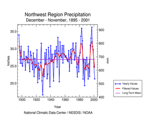
A series of moist Pacific storm systems continued to bring short-term relief from the drought to parts of the western U.S., resulting in the second consecutive month with above-normal precipitation for the Pacific Northwest (see graph below left) and the 18th wettest November for the West region. The 2001-2002 Northwest wet season had a good start as late November-early December snowstorms increased the water content of the snow pack from below average on November 27 to well above-average by December 6. In spite of the 25th wettest October-November, long-term moisture deficits remained with the region having the eleventh driest December-November on record in 2001. The Southwest region had a near-normal November, but the two previous dry months resulted in the 14th driest autumn (September-November) for the region. Highlights:
  • Declared drought emergencies continued in three western states (Washington, Oregon, and Idaho).
  • As a consequence of the 2000-2001 drought, Idaho managers depleted the state's water reserves held in dams.
  • The drought in Montana has had serious effects, including reduced agricultural production to low reservoirs, record or near-record low streamflows, and many long-term wells going dry.
  • Heavy November rains brought short-term relief to western Texas, however severe long-term moisture deficits persisted.
Click here for graph showing Pacific Northwest region precipitation for December 2000-November 2001
larger image
Click here for graphic showing Pacific Northwest Region Precipitation Anomalies, January 1998 - November 2001
larger image
Click here for graphic showing West Region Precipitation Anomalies, January 1998 - November 2001
larger image


Click here to go to Top of Page Eastern U.S. Drought

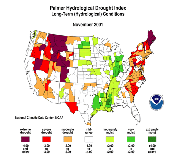
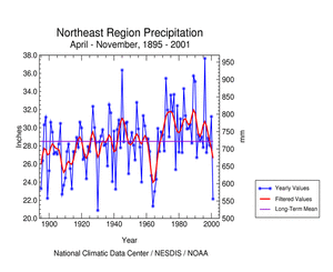
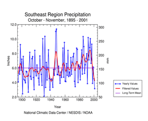
A dry weather pattern in the eastern U.S. intensified during November and resulted in escalating drought effects, including diminishing reservoir supplies, wildfire activity, and poor winter wheat establishment -- during a period in which symptoms of drought are often masked by cool weather and diminishing agricultural and municipal water requirements. November marked the second consecutive dry month across the eastern seaboard. October-November 2001 ranked as the fourth driest in the 107-year record for the Northeast region and sixth driest for the Southeast.

Click here for graphic showing Northeast Region Precipitation Anomalies, January 1998 - November 2001
larger image
Click here for graphic showing Southeast Region Precipitation Anomalies, January 1998 - November 2001
larger image

The persistent dryness during 2001 in the Northeast region is comparable to the deficits experienced at the height of the major Northeast drought of the 1960's (see table to right). Some highlights:
  • According to the USGS in Baltimore, Maryland, low rainfall and warm temperatures in November contributed to record low streamflow and ground-water levels. Streamflow into the Chesapeake Bay was the lowest for November since records began in 1937, and just below the previous record set in 1964.
  • Record or near-record low streamflows and groundwater in Maine have raised the concerns of power companies, water utilities, and homeowners with shallow wells. In 2001, Maine has had a record driest
  • By early December, Upper Delaware Basin reservoir storage declined to drought levels, automatically triggering additional reductions in Delaware River flow targets and water diversions to New York City and New Jersey. An emergency hearing was scheduled for mid-December.
Click here for graphic showing Northeast Region Precipitation, April-November, 1895-2001
larger image

Precipitation Ranks for the
Northeast region, 2000-2001
Period Rank
Nov 11th driest
Oct-Nov 4th driest
Sep-Nov 8th driest
Aug-Nov 6th driest
Jul-Nov 6th driest
Jun-Nov 10th driest
May-Nov 12th driest
Apr-Nov 3rd driest
Mar-Nov 13th driest
Feb-Nov 10th driest
Jan-Nov 7th driest
Dec-Nov 7th driest

The Southeast has been plagued by both short-term and long-term dryness during 2001. Some highlights: Click here for graphic showing Southeast Region Precipitation, October-November, 1895-2001
larger image

Click here to go to Top of Page Additional Contacts:

Damage due to the drought has been summarized by NOAA and the Office of Global Programs in the Climatological Impacts section of the Climate Information Project. Crop impact information can be found at the USDA NASS (National Agricultural Statistics Service) and Weekly Weather and Crop Bulletin pages. Drought statements by local National Weather Service Offices can be found at the NWS Hydrologic Information Center. Drought threat assessments and other information can be found at NOAA's Drought Information Center. Additional drought information can be found at the National Drought Mitigation Center, the USDA's National Agricultural Library, the interim National Drought Council, and the NOAA Paleoclimatology Program. The following states have set up web pages detailing current drought conditions and/or their plans to handle drought emergencies:
Delaware - Delaware River Basin (DE-NJ-NY-PA) - Florida Panhandle - Georgia - Hawaii - Idaho - Kentucky - Maryland - Missouri - Montana-1 - Montana-2 - Nebraska - New Jersey - New Mexico - North Carolina - Oklahoma-1 - Oklahoma-2 - Oregon-1 - Oregon-2 - Pennsylvania-1 - Pennsylvania-2 - South Carolina - Texas - Vermont - Washington - Wyoming

For additional information on the 2001 wildfire season please see the National Interagency Fire Center web site or the U.S. Forest Service Fire and Aviation web site.

NCDC's Drought Recovery Page shows the precipitation required to end or ameliorate droughts and the probability of receiving the required precipitation.

Additional climate monitoring graphics can be found at the Climate Prediction Center's monitoring pages:


Citing This Report

NOAA National Centers for Environmental Information, Monthly Drought Report for November 2001, published online December 2001, retrieved on March 19, 2024 from https://www.ncei.noaa.gov/access/monitoring/monthly-report/drought/200111.