U.S. Drought Highlights:
|
Contents Of This Report: |
National Overview
On the national scale,
|
 larger image |
 larger image |
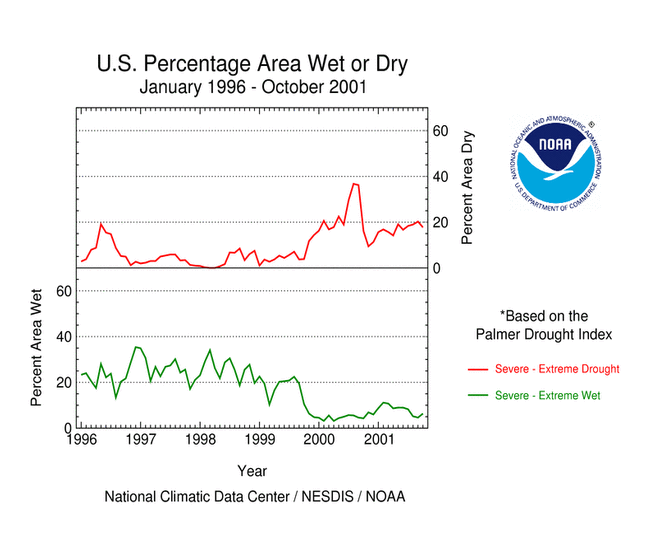
Although some areas of the U.S. had well above normal precipitation, many areas were very dry. October averaged slightly below normal when precipitation is integrated across the nation. Eleven of the last 27 months have averaged well below the normal, while only three averaged well above normal (see graph to right). National 2001 precipitation ranks:
|
 larger image |
Regional Overview
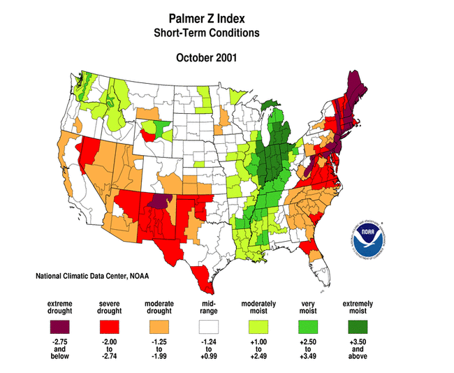
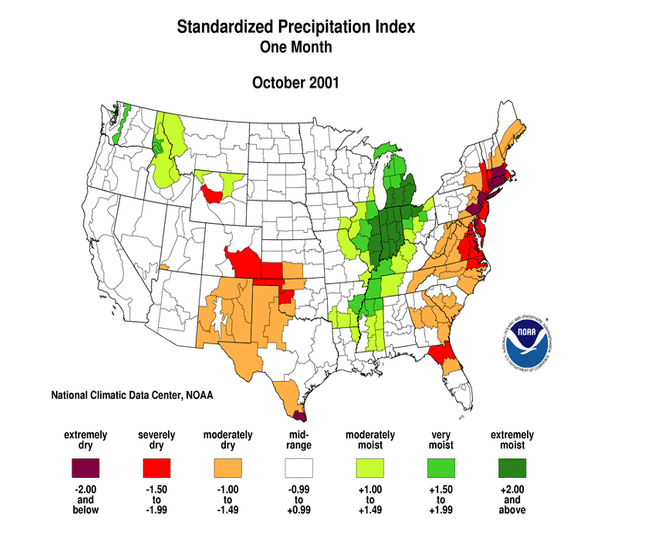
Beneficial rain and snow near the end of the month brought short-term relief from drought to the Pacific Northwest, however long-term drought continued to plague much of the western U.S. October was dry and warmer than normal from the southern Rockies to California, and dry over parts of the southern Plains. A dry October along the eastern seaboard intensified the drought in the Northeast and parts of the Southeast, with wildfires becoming a growing threat. Stations in the northern islands in Hawaii were dry during October, but the signal was mixed in Alaska. This overall pattern is evident in the following indicators:
|
 Western U.S. Drought
| A moist Pacific system brought short-term relief from the drought to the Pacific Northwest near the end of the month, resulting in above-normal precipitation for October (see graph below left). In spite of the 27th wettest October, long-term moisture deficits remained with the region having the second driest November-October on record in 2001. October was dry in the West region and marked the second consecutive month of very dry conditions in the Southwest region (see graph below right). Highlights: |
|
 larger image |
 larger image |
 larger image |
Eastern U.S. Drought
| October was unusually dry across the eastern seaboard, with especially severe moisture deficits occurring in the Northeast. The dryness is evident in both the amount of precipitation that has fallen and the frequency (number of days) it has fallen (see maps below). Eight states, from North Carolina to Massachusetts, had the ninth driest, or drier, October on record in 2001. |
 larger image |
 larger image |
October marked the fourth dry month in a row for the Northeast region (see graph to right). Some highlights:
|
 larger image |
|
In response to the dry conditions, drought watches or warnings were in effect in several counties in Pennsylvania and New York, and New Jersey declared a drought watch for the entire state on October 30. Voluntary conservation measures have been requested in these areas.
The very dry conditions during October led to hundreds of small wildfires in many eastern states from Kentucky and Virginia to South Carolina, and also in Massachusetts. Governor Bob Wise declared a state of emergency for southern West Virginia on October 31, with a total ban on outdoor burning in effect statewide. |
| October 2001 was the 17th driest October in the 107-year record regionwide for the Southeast. In spite of recent wet conditions, long-term precipitation ranks are still below normal, with 2001 marking the third consecutive dry November-October (see graph to right). Pockets of severe drought lingered in Georgia and the Carolinas. Heavy rains from thunderstorms and tropical systems earlier this year have, for the most part, ended the drought over Florida. Only the long-term indicators, such as the 24-month Standardized Precipitation Index, reveal how bad the state's deficits were. |  larger image |

Additional Contacts:
| Damage due to the drought has been summarized by NOAA and the Office of Global Programs in the Climatological Impacts section of the Climate Information Project. Crop impact information can be found at the USDA NASS (National Agricultural Statistics Service) and Weekly Weather and Crop Bulletin pages. Drought statements by local National Weather Service Offices can be found at the NWS Hydrologic Information Center. Drought threat assessments and other information can be found at NOAA's Drought Information Center. Additional drought information can be found at the National Drought Mitigation Center, the USDA's National Agricultural Library, the interim National Drought Council, and the NOAA Paleoclimatology Program. The following states have set up web pages detailing current drought conditions and/or their plans to handle drought emergencies:
For additional information on the 2001 wildfire season please see the National Interagency Fire Center web site or the U.S. Forest Service Fire and Aviation web site. NCDC's Drought Recovery Page shows the precipitation required to end or ameliorate droughts and the probability of receiving the required precipitation. Additional climate monitoring graphics can be found at the Climate Prediction Center's monitoring pages: |