Contents Of This Report:

 National Overview
| On a national scale, drought affected approximately seven percent of the contiguous United States as of the end of November 2000, continuing the recovery from a peak of 36% in August (see graph below left). At its peak, the 2000 drought, when compared to other droughts of the 20th Century, was as extensive as the major droughts of the last 40 years, but not as large as the "dust bowl" droughts of the 1930's and 1950's (see graph below right).
Abundant rains brought drought relief to the southern Plains and Deep South in November. Long-term conditions remained very dry over much of Florida, and short-term dryness developed this month over parts of the Far West and the northeastern quarter of the nation. Although different parts of the U.S. have experienced unusually wet conditions during the last 12 months, there continues to be little change in the overall national wetness picture. The percentage of the nation severely wet has remained near 5% during this period (see graph below left). |
 larger image |
 larger image |
Palmer Drought Indices
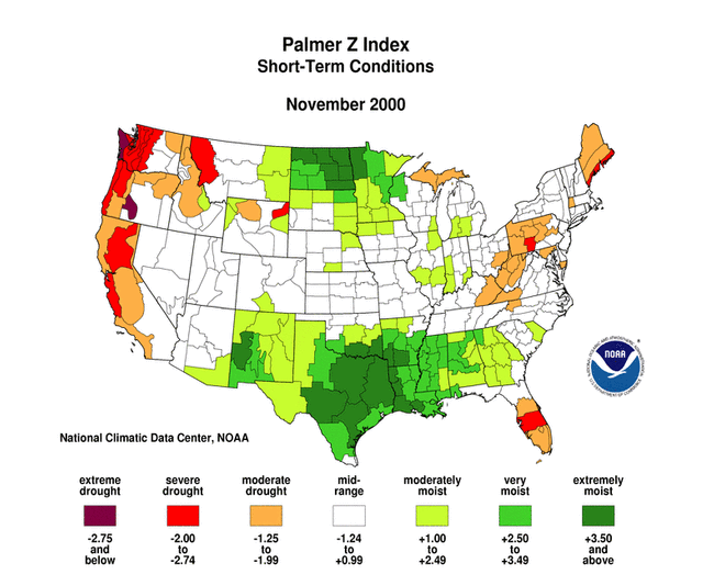
| The Palmer Z Index shows how monthly moisture conditions depart from normal (short-term drought and wetness). November 2000 was severely dry along the west coast and in parts of the Pacific Northwest, central Appalachians, northern New England, and Florida. Rains brought relief from the drought across much of the southern Plains and Deep South states. The animated maps to the right show the geographical pattern of the moisture anomalies for the last 12 months. On these maps, the red shading denotes dry conditions while the green shading indicates wet conditions. | 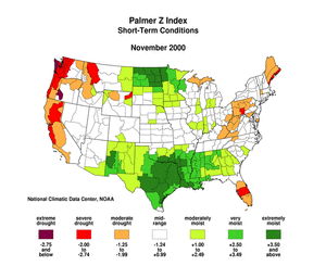 larger animated image |
 larger animated image |
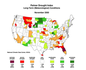
The Palmer Drought Index maps show long-term (cumulative) meteorological drought and wet conditions. Heavy rains of recent weeks indicated that the meteorological patterns giving rise to drought in the Deep South were breaking down. By the end of November, long-term meteorological drought persisted across parts of the Deep South, southern Appalachians, northern Rockies, central Plains, and northern Great Lakes. The animated maps show how the geographical pattern of the long-term (meteorological) moisture conditions has changed over the last 12 months. On these maps, the red shading denotes drought conditions while the green shading indicates wet conditions. |
| The Palmer Hydrological Drought Index maps show long-term (cumulative) hydrological drought and wet conditions, which more accurately reflect groundwater conditions, reservoir levels, etc. The PHDI indicates that hydrological drought persisted through the end of November across most of the Southeast and parts of the West, central Plains, and northern Great Lakes. The animated maps to the right show the geographical pattern of the long-term (hydrological) moisture anomalies for the last 12 months. On these maps, the red shading denotes dry conditions while the green shading indicates wet conditions. | 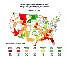 larger animated image |
Regional Drought Watch:
Standardized Precipitation Index
| The Standardized Precipitation Index (SPI) is another way of measuring drought. The SPI is an index based on the probability of recording a given amount of precipitation, and the probabilities are standardized so that an index of zero indicates the median precipitation amount (half of the historical precipitation amounts are below the median, and half are above the median). The index is negative for drought, and positive for wet conditions. As the dry or wet conditions become more severe, the index becomes more negative or positive. While the Palmer Drought Index is a water balance index that considers water supply (precipitation), demand (evapotranspiration) and loss (runoff), the SPI is a probability index that considers only precipitation.
The seven maps below show the November 2000 spatial patterns of SPI for seven different periods ranging from one month (short-term conditions) to 24 months (long-term conditions). When taken together, they give a combined geographical and temporal picture of the severity of precipitation anomalies. The maps illustrate, for example:
|
 larger image |
 larger image |
 larger image |
 larger image |
 larger image |
 larger image |
 larger image |
Deep South Drought
| November was a wet month across much of the U.S. Deep South (AL, FL, GA, LA, MS), ranking as the sixth wettest November in the 106-year record. The recent rains indicated that the short-term drought had ended across much of the region, with the November region-wide Palmer Z Index in the moderately moist category. However, long-term conditions remained quite dry. Significant precipitation deficits remained on the 9-month to 24-month time scales, with December 1999-November 2000 ranking as the fourth driest such 12-month period on record region-wide (see graph below). |
|

| Much of the November precipitation passed Florida by. The state had the 40th driest November on record in 2000, while other states in the Deep South ranked in the top 20 wettest category. Only one month in the last 12 had above normal precipitation (see graph below left), giving the state the second driest December-November on record (see graph below right) and the driest January-November in the 106-year record. By early December, water managers in southern Florida imposed mandatory water-use restrictions in response to the drought which has brought Lake Okeechobee to near-record low levels. |
 larger image |

Southern Plains Recovery
| November marked the second consecutive month with above-normal precipitation region-wide across the South region (see graph to right). In fact, 2000 had the wettest November on record. The very wet October-November conditions brought an end to the drought over most of the region. December 1999-November 2000 ranked in the mid-range for the region, with only a few areas still experiencing long-term deficits (on the 12-month and 24-month time scales). |  larger image |
Drought in the West
| Two regions in the western U.S. experienced dry conditions during November 2000. The Northwest region had the 13th driest November on record. This marks a dry beginning to the region's wet season. The West region had the 11th driest November on record in 2000. As for the Northwest, this marks a dry beginning to the West region's wet season.
The northern Rockies experienced an extremely dry summer, but rain and snow during the last couple months have brought some recovery to the area. While Montana received near-normal precipitation during October and November, much of the state still suffers from long-term drought, with December 1999-November 2000 ranking as the 15th driest such 12-month period on record (see graph to right). |
 larger image |
Drought in the Northeast U.S.
| November 2000 marks the fourth consecutive month with below-normal precipitation across the Northeast region (see graph to right). However, the unusually wet conditions earlier in the year have, to date, offset any major impacts of the recent dryness. In fact, December 1999-November 2000 ranks as the 35th wettest (71st driest) such 12-month period on record and January-November 2000 ranks as the 25th wettest such 11-month period on record. |  larger image |
Additional Contacts:
| Damage due to the drought has been summarized by NOAA and the Office
of Global Programs in the Climatological Impacts section of the Climate
Information Project. Crop impact information can be found at the USDA NASS (National Agricultural Statistics Service) and Weekly Weather and Crop Bulletin pages. Drought
statements by local National Weather Service Offices can be found at the NWS Hydrologic Information Center. Drought
threat assessments and other information can be found at NOAA's Drought Information Center. Additional drought
information can be found at the National Drought Mitigation
Center, the USDA's National Agricultural Library,
and the NOAA Paleoclimatology Program. The following states have set up web pages detailing their drought emergencies:
New Mexico - North Carolina - Oklahoma - South Carolina - Texas For additional information on the 2000 wildfire season please see the National Interagency Fire Center web site or the U.S. Forest Service Fire and Aviation web site. Additional climate monitoring graphics can be found at the Climate Prediction Center's monitoring pages: |