Contents Of This Report:


 National Overview
| On a national scale, the 2000 drought affected just over a third (34%) of the contiguous United States as of the end of September. When compared to other droughts of the 20th Century, the 2000 drought is as extensive as the major droughts of the last 40 years, but not as large as the "dust bowl" droughts of the 1930's and 1950's (see graph to right).
As the percent of the U.S. experiencing severe drought increased over the last 12 months, the percentage severely wet has declined. As of the end of September 2000, approximately 4% of the country experienced severe to extreme wet spell conditions. |
 larger image |
| Although long-term drought conditions have not broken records on a national scale in 2000, record dryness has occurred in several regions on various time scales. For example, the Deep South experienced the driest December-September on record in 2000, with Alabama and Louisiana having the second driest July-September and Louisiana having the driest November-September on record. Texas and Oklahoma had the driest August-September since records began in 1895, and October-September was the driest such period on record for Arizona. Details are discussed in the regional reports below. |
Palmer Drought Indices
| The Palmer Z Index shows how monthly moisture conditions depart from normal (short-term drought and wetness). September 2000 was severely dry from the upper Mississippi Valley to the southern Plains, across the Southwest, and in parts of the Southeast and northern New England. Rains brought relief from the drought in parts of the extreme Southeast and the northern Rockies. The animated maps to the right show the geographical pattern of the moisture anomalies for the last 12 months. On these maps, the red shading denotes dry conditions while the green shading indicates wet conditions. | 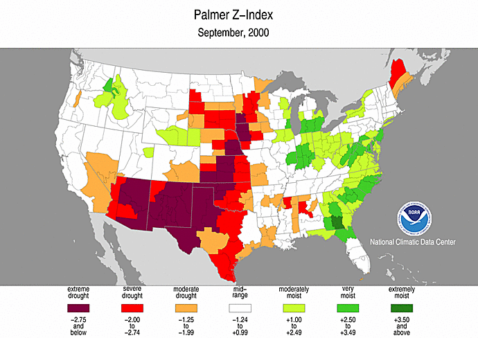 larger animated image |
 larger animated image |
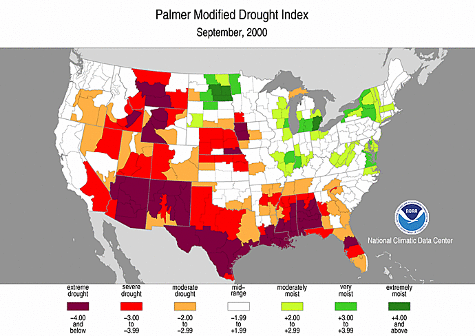
The Palmer Drought Index maps show long-term (cumulative) drought and wet conditions. By the end of September, severe to extreme long-term drought stretched in a near-continuous band from the southeastern U.S. to the southern Plains, then up along the Rocky Mountain states and into the Far West, with a pocket of severe drought in the central Plains. Beneficial August and September rains from the remnants of Hurricane Gordon and Tropical Storm Helene eroded the drought in the eastern portions of the Deep South. September rains and snowfalls brought drought and wildfire relief to portions of the northern Rockies. The animated maps show how the geographical pattern of the long-term moisture conditions has changed over the last 12 months. On these maps, the red shading denotes drought conditions while the green shading indicates wet conditions. |
| The Palmer Crop Moisture Index is computed on a weekly basis by the National Weather Service's Climate Prediction Center and is useful for following the impact of precipitation anomalies on agriculture. The animated CMI maps to the right show how the geographical pattern of topsoil moisture conditions has changed from March 4th through September 30th, the growing season-to-date. Crop moisture conditions improved during September over the northern and central portions of the country, but conditions remain severely dry from the Southwest and southern Plains into the Southeast. |  larger animated image |
Regional Drought Watch:
Standardized Precipitation Index
| The Standardized Precipitation Index (SPI) is another way of measuring drought. The SPI is an index based on the probability of recording a given amount of precipitation, and the probabilities are standardized so that an index of zero indicates the median precipitation amount (half of the historical precipitation amounts are below the median, and half are above the median). The index is negative for drought, and positive for wet conditions. As the dry or wet conditions become more severe, the index becomes more negative or positive. While the Palmer Drought Index is a water balance index that considers water supply (precipitation), demand (evapotranspiration) and loss (runoff), the SPI is a probability index that considers only precipitation.
The six maps below show the September 2000 spatial patterns of SPI for six different periods ranging from one month (short-term conditions) to twelve months (long-term conditions). When taken together, they give a combined geographical and temporal picture of the severity of precipitation anomalies. The maps illustrate, for example:
|
 larger image |
 larger image |
 larger image |
 larger image |
 larger image |
 larger image |
Deep South Drought
| By the end of September, beneficial rains from the remnants of Hurricane Gordon and Tropical Storm Helene had eroded the drought in the eastern portions of the U.S. Deep South (AL, FL, GA, LA, MS). The regional Palmer Z Index indicated conditions averaged across these 5 states were near normal for the month, a considerable improvement from the previous 4 months (see graph below left).
However, long-term conditions remained dry over much of the region. The 2000 hydrologic year, October-September, ranked as the fourth driest such 12-month period in the 106-year record (see graph below right). In spite of the near-normal September rainfall, the Deep South had the driest November-September and December-September on record this year (see table to right). |
|
 larger image |

Southern Plains Drought
| The very dry spell of the last 3 months in the southern Plains (see graph to right) continued during the month of September 2000. Texas and Oklahoma had the driest August - September since records began in 1895, with many stations setting new records. The South region as a whole had the driest July - September on record (see graph below left). The drought of the last 15 months was interrupted by wetter conditions during spring and early summer, but the hydrologic year still ranked as the seventh driest October - September on record (see graph bottom right). |  larger image |
 larger image |

Western Drought and Wildfires
| Much of the western United States suffered from unusually dry conditions as of the end of September 2000. Earlier NCDC reports discussed the associated wildfires which ravaged the region during July and August. Beneficial rains (and snowfall in the northern and central Rockies) during September helped extinguish many of the fires and eased the drought in some areas. In Montana, for example, September 2000 precipitation averaged near normal, giving the state a rank of 49th wettest.
|
 larger image |
Southwest Drought
| The southwestern United States is largely desert with areas of mountain forests, concentrated urban areas, and some irrigated farming. It's hard to think of a desert experiencing drought, but below-normal precipitation can have important impacts, including lowered water tables, reduced streamflow, and increased wildfires. The last 3 months have been unusually dry in this area (see graph to right), with New Mexico experiencing the second driest July - September (see graph below left), and fourth driest September and October - September (see graph below right). Arizona had the driest October - September on record during 2000. |  larger image |
 larger image |

Additional Contacts:
| Crop impact information can be found at the USDA NASS (National Agricultural Statistics Service) and Weekly Weather and Crop Bulletin pages. Drought statements by local National Weather Service Offices can be found at the NWS Hydrologic Information Center. Drought threat assessments and other information can be found at NOAA's Drought Information Center. Additional drought information can be found at the National Drought Mitigation Center, the USDA's National Agricultural Library, and the NOAA Paleoclimatology Program. The following states have set up web pages detailing their drought emergencies:
New Mexico - North Carolina - Oklahoma - South Carolina - Texas For additional information on the 2000 wildfire season please see the National Interagency Fire Center web site or the U.S. Forest Service Fire and Aviation web site. |