Contents Of This Report:


 National Overview
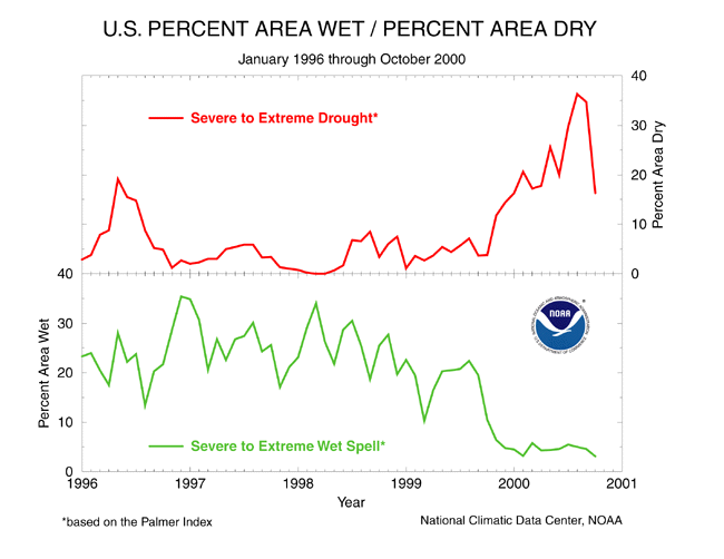
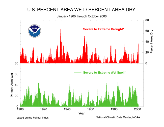
| On a national scale, drought affected approximately one sixth (16.3%) of the contiguous United States as of the end of October 2000, down from a peak of 36% in August (see graph below left). When compared to other droughts of the 20th Century, the 2000 drought is as extensive as the major droughts of the last 40 years, but not as large as the "dust bowl" droughts of the 1930's and 1950's (see graph below right).
October rains brought drought relief to some areas, but parts of the southern and eastern U.S. had record dryness this month. Virginia, North Carolina, and South Carolina had the driest October on record, while the Palmer Drought Index reached near record levels in the Deep South. Details are discussed in the regional reports below. Although different parts of the U.S. have experienced unusually wet conditions during the last 12 months, there has been little change in the overall national wetness picture. The percentage of the nation severely wet has remained near 5% during this period (see graph below left). |
 larger image |
 larger image |
Palmer Drought Indices
| The Palmer Z Index shows how monthly moisture conditions depart from normal (short-term drought and wetness). October 2000 was severely dry from the Gulf Coast to Mid-Atlantic and in parts of the Great Lakes, Upper Mississippi Valley, and coastal Pacific Northwest. Rains brought relief from the drought across much of the western and Great Plains states. The animated maps to the right show the geographical pattern of the moisture anomalies for the last 12 months. On these maps, the red shading denotes dry conditions while the green shading indicates wet conditions. | 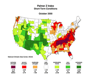 larger animated image |
 larger animated image |
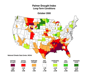
The Palmer Drought Index maps show long-term (cumulative) drought and wet conditions. By the end of October, severe to extreme long-term drought persisted in a near-continuous band from the southeastern U.S. to the southern Plains. Pockets of severe drought remained in the central Plains and Far West and were developing in the northern Great Lakes. Beneficial rains from several Pacific storm systems brought drought relief to many areas of the western and Plains states. The animated maps show how the geographical pattern of the long-term moisture conditions has changed over the last 12 months. On these maps, the red shading denotes drought conditions while the green shading indicates wet conditions. |
Regional Drought Watch:
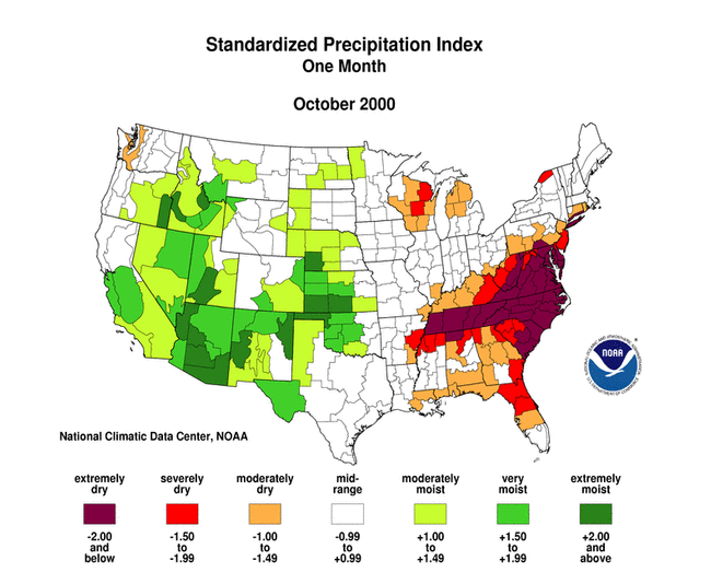
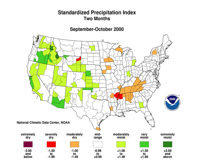
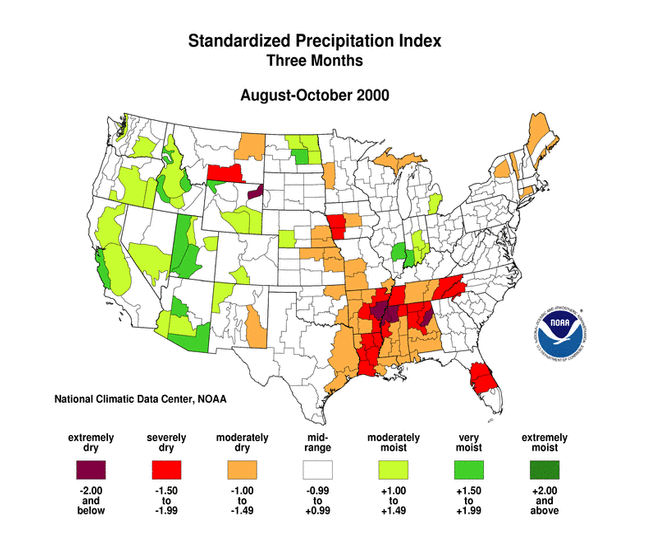
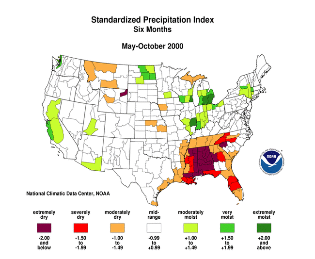
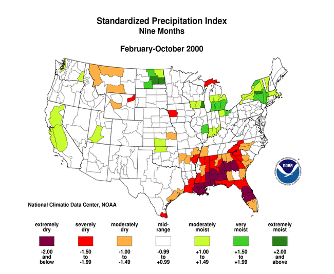
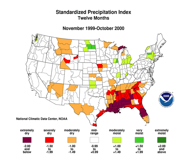
Standardized Precipitation Index
| The Standardized Precipitation Index (SPI) is another way of measuring drought. The SPI is an index based on the probability of recording a given amount of precipitation, and the probabilities are standardized so that an index of zero indicates the median precipitation amount (half of the historical precipitation amounts are below the median, and half are above the median). The index is negative for drought, and positive for wet conditions. As the dry or wet conditions become more severe, the index becomes more negative or positive. While the Palmer Drought Index is a water balance index that considers water supply (precipitation), demand (evapotranspiration) and loss (runoff), the SPI is a probability index that considers only precipitation.
The seven maps below show the October 2000 spatial patterns of SPI for seven different periods ranging from one month (short-term conditions) to 24 months (long-term conditions). When taken together, they give a combined geographical and temporal picture of the severity of precipitation anomalies. The maps illustrate, for example:
|
 larger image |
 larger image |
 larger image |
 larger image |
 larger image |
 larger image |
 larger image |
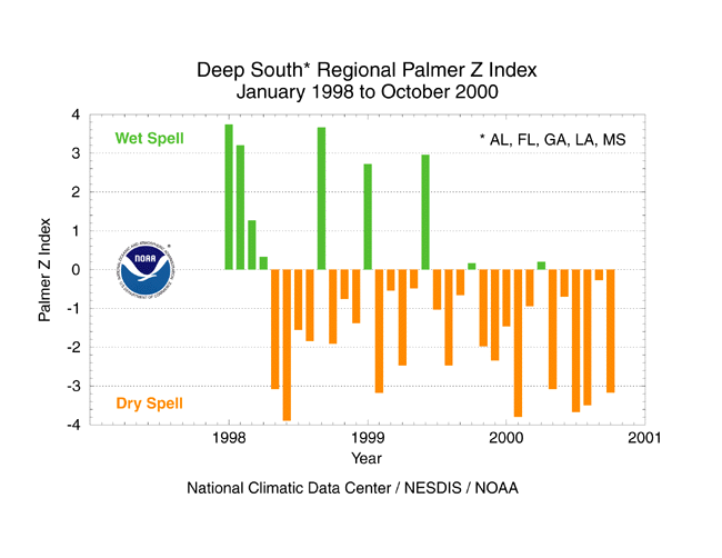
Deep South Drought
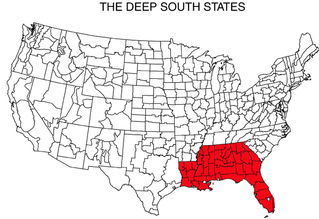
| October was another dry month across much of the U.S. Deep South (AL, FL, GA, LA, MS). The regional Palmer Z Index indicated conditions averaged across these 5 states were in the extreme drought category (see graph below left). Georgia farmers have stopped planting of small grains due to the dry conditions, and the drought has dropped lake levels of Alabama Power reservoirs to record lows. Many streams in the Deep South have experienced record low flows and cities have imposed water restrictions, with Carrollton, Georgia declaring a state of emergency.
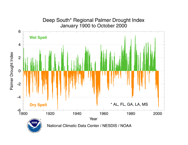
The cumulative effects of the persistently dry conditions over the last two and a half years (see graph below left) have resulted in a near-record long-term Palmer Drought Index (see graph below right). The October 2000 PDI for the Deep South region is second only to the PDI of August 1925. The table to the right shows how pervasive record and near-record precipitation deficits have been for this region in 2000. The period of record for this table goes back 106 years. |
|
 larger image |
Southeast and Mid-Atlantic Drought
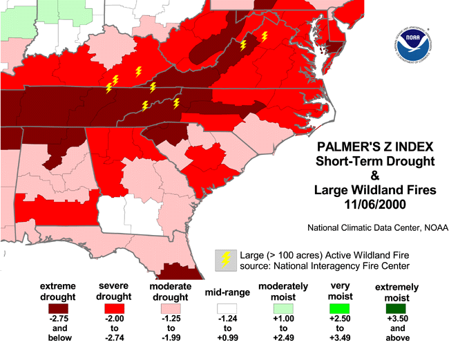
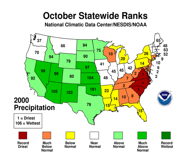
| October 2000 was extremely dry across the Mid-Atlantic and southeastern states. Virginia, North Carolina, and South Carolina had the driest October on record, with several stations reporting no precipitation or record low precipitation during the month (see map to right). Wildfires became more numerous by the end of the month (see graph below left). In addition to persistent dryness, much of the area experienced persistent temperatures with below-normal day-to-day temperature variability. | 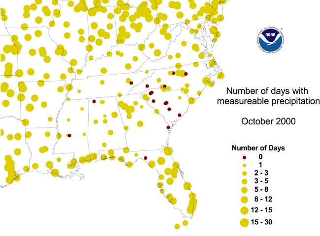 larger image |
 larger image |
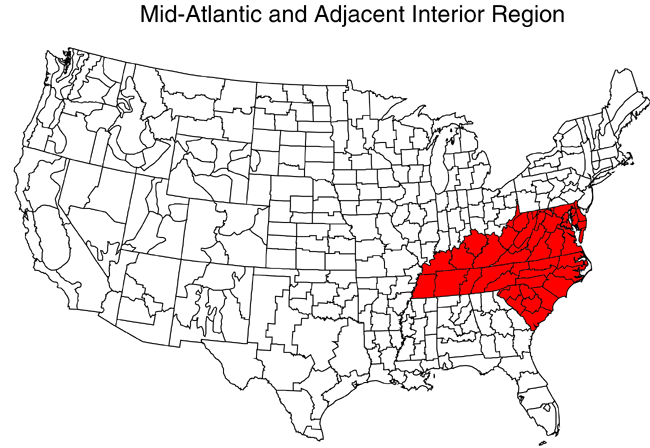
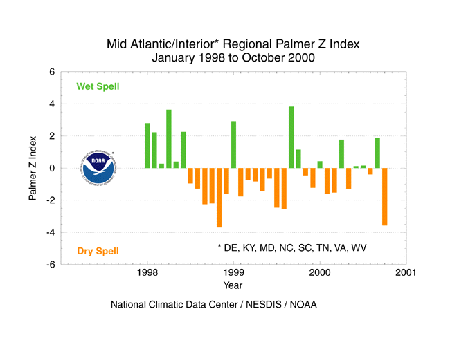
| The Mid-Atlantic and adjacent interior region (DE, KY, MD, NC, SC, TN, VA, WV) experienced an extremely dry October. The deficit was short-term, however, with abundant precipitation in earlier months over much of the region resulting in mid-range anomalies over three months and a regional Palmer Drought Index near normal.
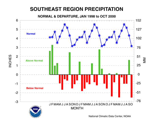
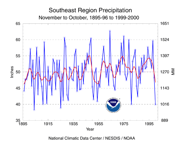
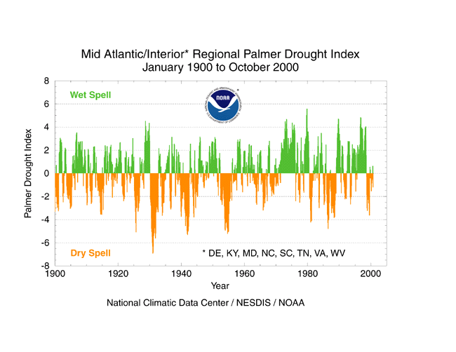
The extreme October precipitation deficits in the Southeast region continued a pattern of drought which has lasted nearly three years (see graph below left). Only one month (September) of the last twelve had much above normal precipitation. November 1999-October 2000 ranked as the third driest such 12-month period on record (see graph below right). |
 larger image |
Drought in the Great Plains and Far West
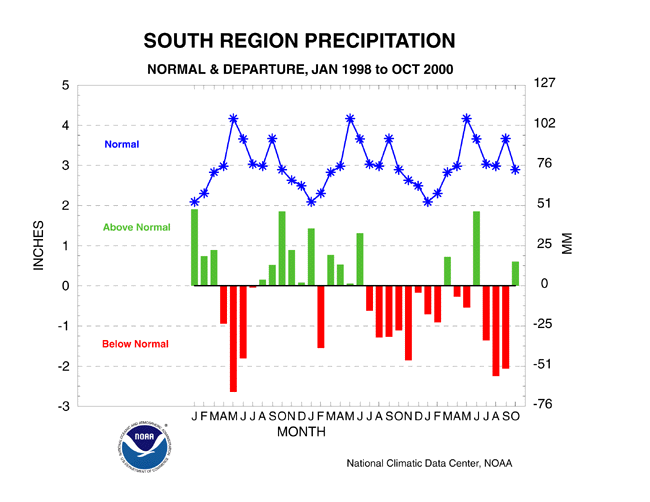
| October rains brought relief to the southern Plains, which was plagued by severe drought this summer (see graph below left). The summer rainfall deficit was so great that July-October 2000 ranked as the fifth driest such four-month period on record for the South region (see graph below right).
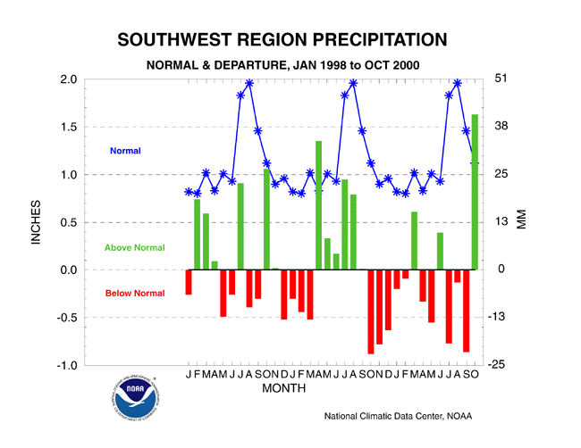
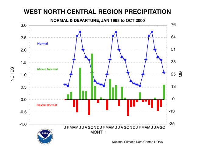
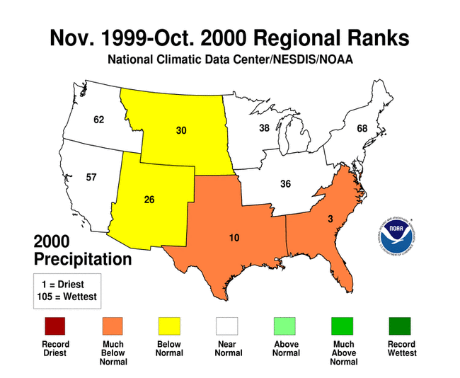
Beneficial rains also brought relief to the drought areas of the Far West and northern and central Plains. Of the standard regions that comprise this part of the country, the West, Southwest, and West North Central regions had above-normal precipitation during October and the Pacific Northwest had a wetter-than-normal September and October. The deficits of most of the last twelve months, however, kept November 1999-October 2000 precipitation ranks in the dry third of the historical distribution for several areas. The West North Central region had the 30th driest and Southwest region the 26th driest such 12-month periods on record.
|
 larger image |
 larger image |
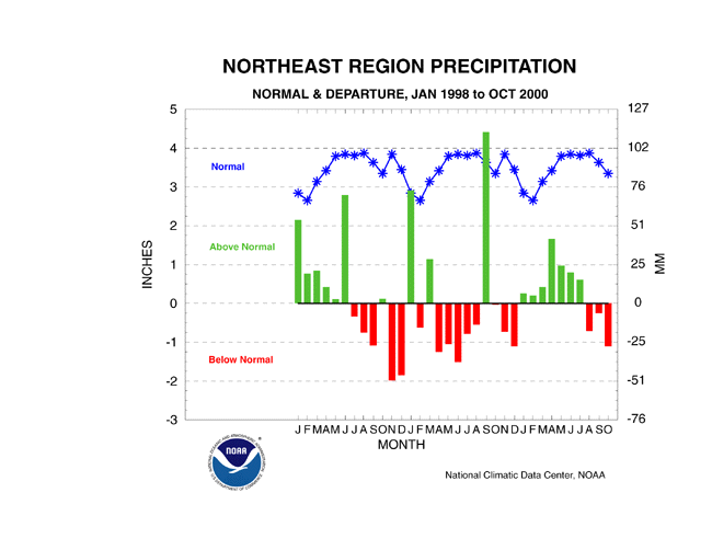
Drought in the North Central and Northeast U.S.
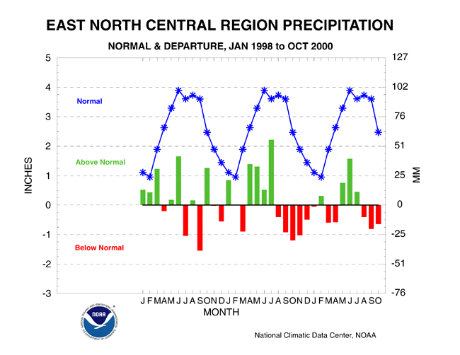
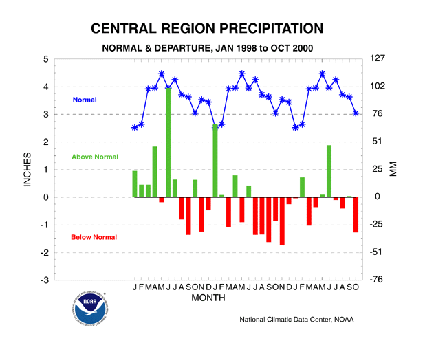
| The last three months generally have been drier than normal for the area stretching from the Upper Mississippi Valley, Great Lakes, and Ohio Valley to the Northeast. The East North Central region had the 26th driest August-October on record in 2000, the Central region ranked 27th driest, and Northeast region 22nd driest. The recent dryness has been offset by above-normal precipitation earlier in the year, with all three regions ranking in mid-range (near normal) for the November 1999-October 2000 period. |  larger image |
Additional Contacts:
| Damage due to the drought has been summarized by NOAA and the Office of Global Programs in the Climatological Impacts section of the Climate Information Project. Crop impact information can be found at the USDA NASS (National Agricultural Statistics Service) and Weekly Weather and Crop Bulletin pages. Drought statements by local National Weather Service Offices can be found at the NWS Hydrologic Information Center. Drought threat assessments and other information can be found at NOAA's Drought Information Center. Additional drought information can be found at the National Drought Mitigation Center, the USDA's National Agricultural Library, and the NOAA Paleoclimatology Program. The following states have set up web pages detailing their drought emergencies:
New Mexico - North Carolina - Oklahoma - South Carolina - Texas For additional information on the 2000 wildfire season please see the National Interagency Fire Center web site or the U.S. Forest Service Fire and Aviation web site. |