larger image
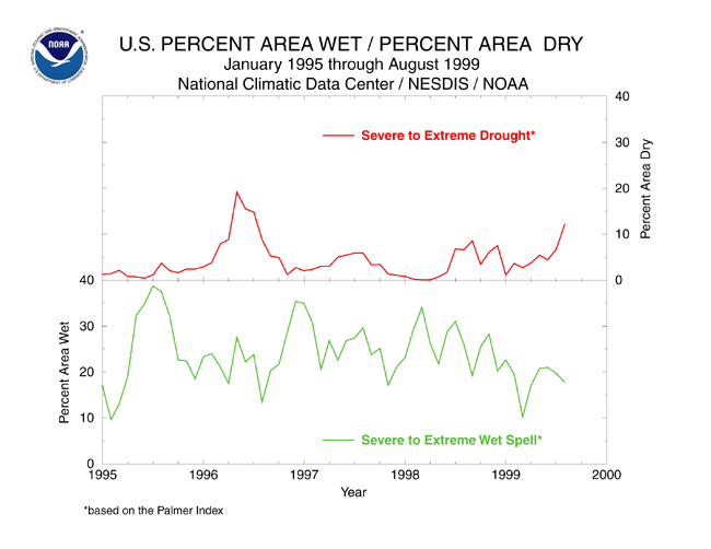
Above: Percent area of the contiguous U.S. experiencing severe to extreme long-term drought and wet spell conditions (as defined by the Palmer Drought Index), January 1995-August 1999.
During the summer (June-August) of 1999, the United States experienced an intensifying drought and heat wave. The east coast was the area hardest hit by the drought, with record and near-record short-term precipitation deficits occurring on a local and regional scale resulting in agricultural losses and drought emergencies being declared in several states. According to NOAA's Rapid Response Project, the USDA estimates that the drought could cost eastern farmers as much as $1.1 billion in lost income. In addition, wildfires had developed in many parts of the western U.S. by late summer, and short-term moisture deficits were plaguing much of the southern Plains and Southeast. By early September, the remnants of Hurricane Dennis brought much-needed rain to parts of the mid-Atlantic and Northeast states.
Crop impact information can be found at the USDA NASS (National Agricultural Statistics Service) and Weekly Weather and Crop Bulletin pages. Drought statements by local National Weather Service Offices can be found at the NWS Hydrologic Information Center. Drought threat assessments and other information can be found at NOAA's Drought Information Center. Additional drought information can be found at the National Drought Mitigation Center. The following states have set up web pages detailing their drought emergencies:
Delaware - Georgia - Maryland - New Jersey - Pennsylvania - South Carolina

Contents of This Report:
- Palmer Drought Indices
- Drought and Streamflow
- Regional Drought Watch
- Is This The Worst Drought on Record?
- Standardized Precipitation Index
- Summer 1999 Rainy Days
- The Summer 1999 Heat Wave
 Palmer Drought Indices
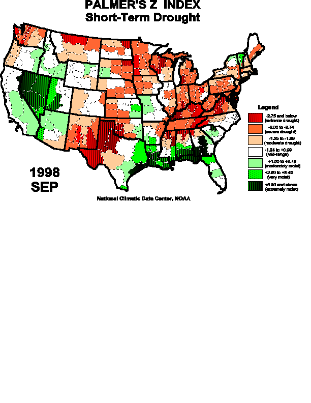
The Palmer Z Index shows how monthly moisture conditions depart from normal (short-term drought and wetness). A large area of the eastern and southern U.S. experienced severe to extreme short-term drought during August 1999, while extremely wet conditions occurred in parts of the northern and central Great Plains, southern Rockies, and Northwest. Hurricane Bret brought wet conditions to the Rio Grande Valley of southern Texas and northeastern Mexico. The animated maps show the geographical pattern of the moisture anomalies for the last 12 months. On these maps, the red shading denotes dry conditions while the green shading indicates wet conditions.
Z Index Legend:
|
 larger animated image |
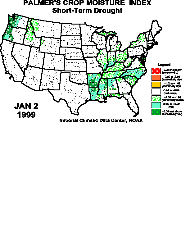
The Palmer Crop Moisture Index is computed on a weekly basis by the National Weather Service's Climate Prediction Center and is useful for following the impact of precipitation anomalies on agriculture. The Animated Crop Moisture Index maps show the change in topsoil moisture conditions during the first 36 weeks of 1999. The CMI shows how short-term agricultural drought expanded and intensified during the summer months across much of the eastern and western U.S. During August, the area of short-term drought along the east coast rapidly expanded westward and southward. On these Crop Moisture Index maps, the red shading denotes dry conditions while the green shading indicates wet conditions.
larger animated imagePalmer Drought Index Legend:
-4.00 and below (extreme drought)
-3.00 to -3.99 (severe drought)
-2.00 to -2.99 (moderate drought)
-1.99 to +1.99 (mid-range)
+2.00 to +2.99 (moderately moist)
+3.00 to +3.99 (very moist)
+4.00 and above (extremely moist)
Crop Moisture Index Legend:
-3.00 and below (severely dry)
-2.00 to -2.99 (excessively dry)
-1.00 to -1.99 (abnormally dry)
-0.99 to +0.99 (mid-range)
+1.00 to +1.99 (abnormally moist)
+2.00 to +2.99 (wet)
+3.00 and above (excessively wet)
larger animated image
Drought and Streamflow
Streamflow measurements by the United States Geological Survey reveal unusually low daily streamflows associated with the drought from the mid-Atlantic to northeastern states during July and August. Streamflow increased for a day or two as August thunderstorms moved through the area. River stages were above normal during most of these two months in the northern and central Plains. As noted by the Western Regional Climate Center, the persistent above-normal streamflow in parts of the Pacific Northwest was likely due to runoff from ground saturated by very heavy winter snowpacks. Late August and early September field reports from the Forest Service and the USDA's National Water & Climate Center indicate that there is still snow in the higher elevations and shaded areas of the Pacific Northwest mountains. Explanation:
New record high for day
90th percentile
75th - 89th percentile
25th - 74th percentile
10th - 24th percentile
10th percentile
New record low for day
larger animated imageMore streamflow information can be found at the United States Geological Survey's web page.


Regional Drought Watch
Regions Discussed: 
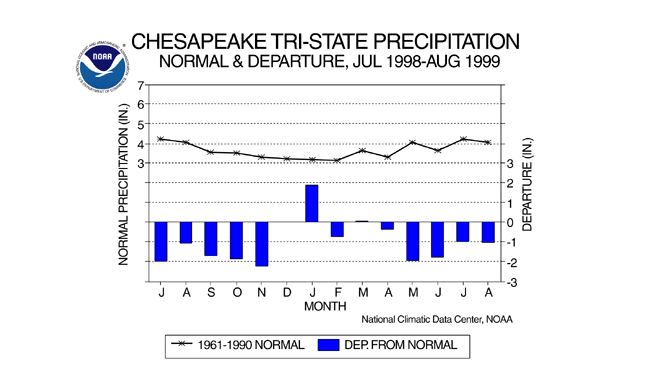
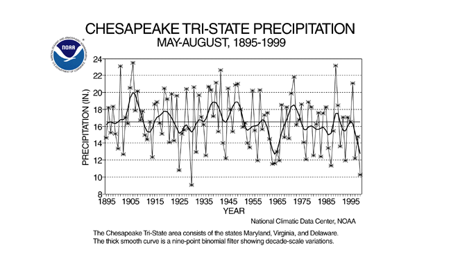
Mid-Atlantic Precipitation Deficit
The mid-Atlantic region (Chesapeake Bay area) has been suffering from drought since last summer. The dry conditions during August 1999 continued the pattern, with 11 of the last 14 months drier than normal. Precipitation for each of the last four months has been an inch or more below normal, giving 1999 the second driest May-August on record (1930 had the century's driest May-August). This 4-month period has had sub-normal precipitation for the last three years (see graph below). Other 1999 statistics include: second driest May-June (behind 1964), third driest April-August (behind 1930 and 1963), and virtual tie with 1966 for third driest summer (behind 1930 and 1983).
larger image
larger image
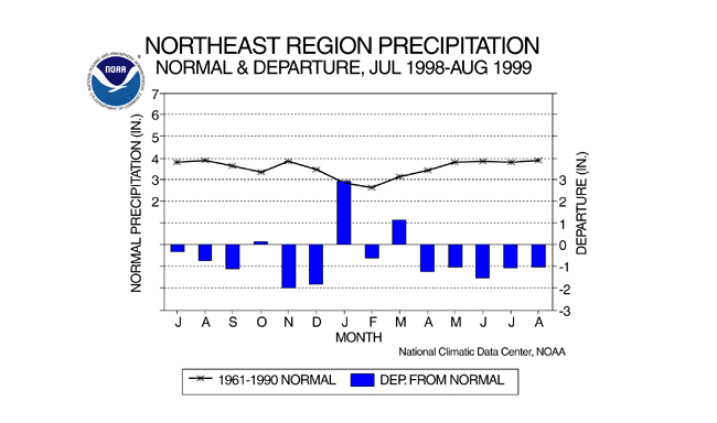
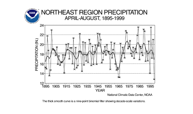
Northeastern U.S. Precipitation Deficit
The Northeast region (which includes the states from Delaware, Maryland, and Pennsylvania northeastward to Maine) has suffered from unusually dry conditions during the last five months, with April-August 1999 ranking as the driest such period this century. Eleven of the last 14 months have been drier than normal. Other 1999 statistics include: second driest summer and sixth driest September-August. Unusually wet weather in January and March 1999 has helped keep the current year's drought from being even more severe.
larger image
larger image
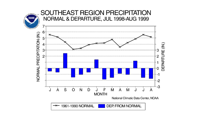
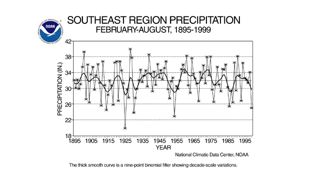
Southeast Region Precipitation Deficit
Eleven of the last 14 months have averaged drier than normal across the Southeast region (Alabama to Florida, then northward to Virginia). February-August 1999 ranked as the fifth driest such period in the 105-year record, beating the equivalent period during the 1985-88 Southeast drought. Other 1999 statistics include: 16th driest summer and year-to-date.
larger image
larger image
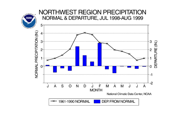
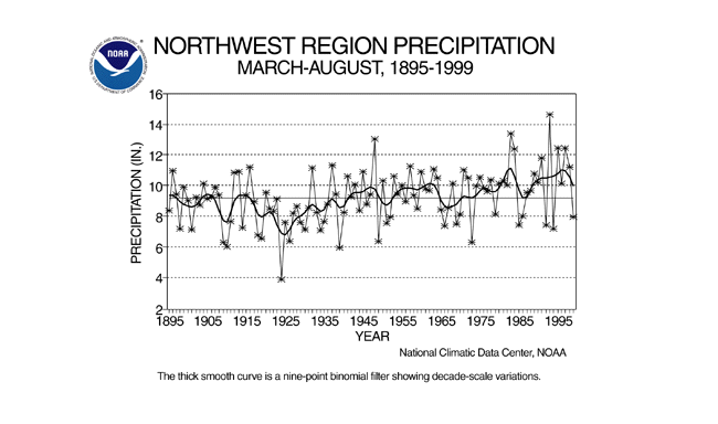
Northwest Region Precipitation Deficit
Dry conditions during spring and summer 1999 in the Northwest region (Washington, Oregon, and Idaho) have resulted in expanding short-term drought (as measured by the Crop Moisture Index) into the region. March-August 1999 was the 25th driest March-August on record. However, the Pacific Northwest has a pronounced seasonal precipitation pattern, with November-March being the wet season. Water managers in this region are dependent on rivers fed by mountain snowpacks, which were unusually heavy this year due to the second wettest November-February on record.
larger image
larger image
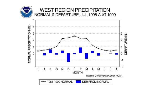
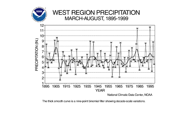
West Region Precipitation
A number of forest and range fires in the western U.S. were reported by the news media near the end of summer. March-August 1999 was the 40th driest such 6-month period on record in the West region (California-Nevada). June-August ranked as the 36th wettest summer on record, but it should be pointed out that this part of the country has a pronounced seasonal precipitation pattern, with the warm half-year being the dry season.
larger image
larger image
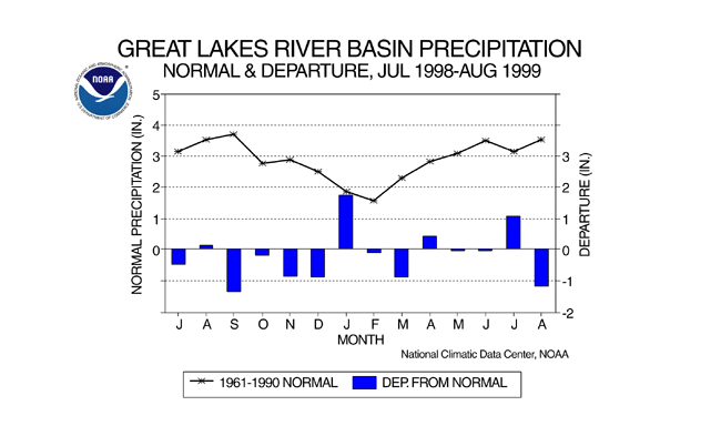
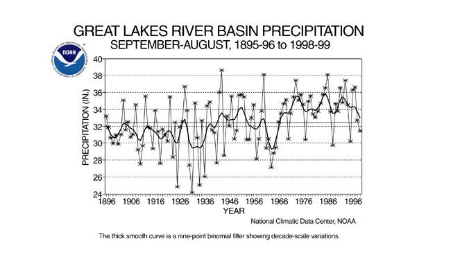
Great Lakes River Basin Precipitation
Late summer media reports have noted the falling levels of the Great Lakes. While the animated Palmer Index maps indicate that this region has experienced periods of long-term drought during the last 12 months, the overall precipitation pattern has not been unusually dry. September 1998-August 1999 ranks as only the 40th driest such 12-month period this century. More noticeable in the graph below right is the trend for wetter conditions over the Great Lakes during the last 30 years. The relative dryness of the last two years stands out prominently against the much wetter 30-year mean.
larger image
larger image
Is This The Worst Drought on Record?
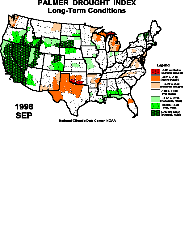
The Palmer Drought Index (PDI) has been used for U.S. drought monitoring for the last 30 years. It is based on a water budget model that incorporates the balance between water supply (i.e., precipitation), soil moisture, runoff, and water demand (computed from estimates for evaporation and transpiration). The PDI is a long-term drought index which incorporates the current conditions (i.e., for the current month) and the past conditions (the preceding several months). The PDI is useful for showing how the current drought compares to past droughts.
The percent area of the contiguous United States affected by severe to extreme long-term drought and wet spell conditions has been computed for each month this century and is useful for examining droughts on a national scale. By this measure, the 1999 drought is minor compared to the widespread drought episodes of the 1930's and 1950's, and even compared to the drought of ten years ago. As of the end of August 1999, severe to extreme drought affected just 12 percent of the country.
larger image
Plots of the monthly PDI for January 1900-August 1999 are shown below for Maryland, New Jersey, Pennsylvania, and Virginia. In all four cases, conditions during the past 12 months rapidly deteriorated into severe to extreme (PDI values of -3.0 to -4.0 and greater) long-term drought. However, the PDI indicates that the 1999 drought is not the worst long-term drought on record. In all states, the drought of the 1960's had a greater magnitude (PDI level as bad or more severe) and lasted much longer (three to four years). For three states, the worst drought (as measured by the magnitude of the PDI) occurred in 1930-31.

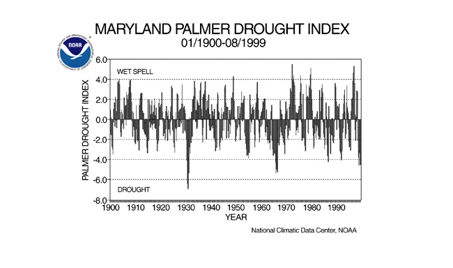 larger image |
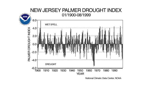 larger image |
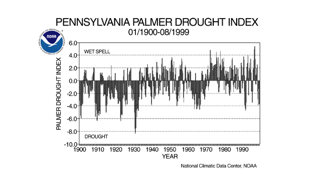 larger image |
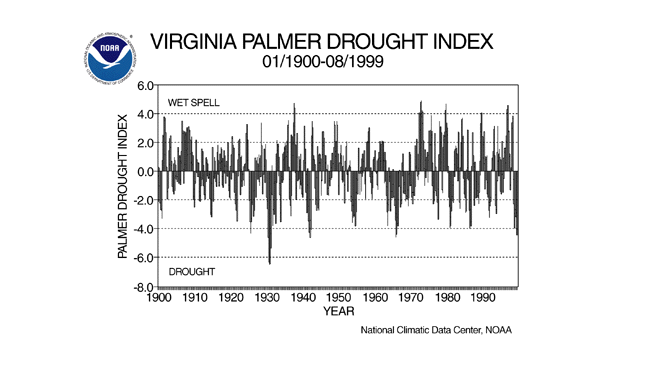 larger image |
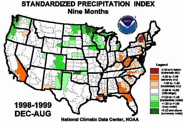
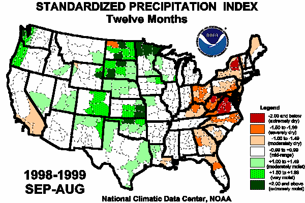
The Standardized Precipitation Index (SPI) is another way of measuring drought. The SPI is an index based on the probability of recording a given amount of precipitation. The probabilities are computed by mixing the likelihood of not receiving any precipitation, as in deserts, with the likelihood of receiving a given amount precipitation when precipitation falls. The probabilities are standardized so that an index of zero indicates the median precipitation amount (half of the historical precipitation amounts are below the median, and half are above the median). The index is negative for drought, and positive for wet conditions. As the dry or wet conditions become more severe, the index becomes more negative or positive. While the Palmer Drought Index is a water balance index that considers water supply (precipitation), demand (evapotranspiration) and loss (runoff), the SPI is a probability index that considers only precipitation. SPI Legend:
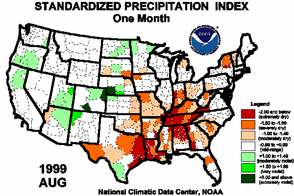
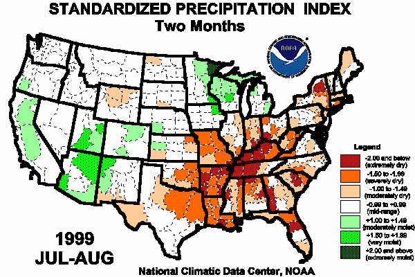
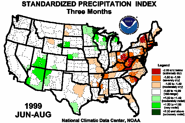
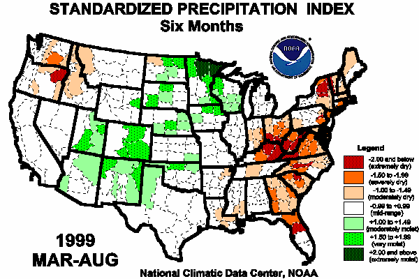
The six maps below show the August 1999 spatial patterns of SPI for six different time frames ranging from one month (short-term conditions) to twelve months (long-term conditions). When taken together, they give a combined geographical and temporal picture of the severity of the precipitation deficits. The maps indicate, for example, that the eastern third of the U.S. has been experiencing both recent short-term dryness and dryness over the long term (past year), the dryness in the Northwest is a recent (back to six months) phenomenon, parts of the Southwest have been dry over the long term (12 months) but have been wet recently, and the central U.S. has been wet over the long term and also wet (in parts, especially the western Great Lakes) recently.
larger image
larger image
larger image
larger image
larger image
larger image
Summer 1999 Rainy Days
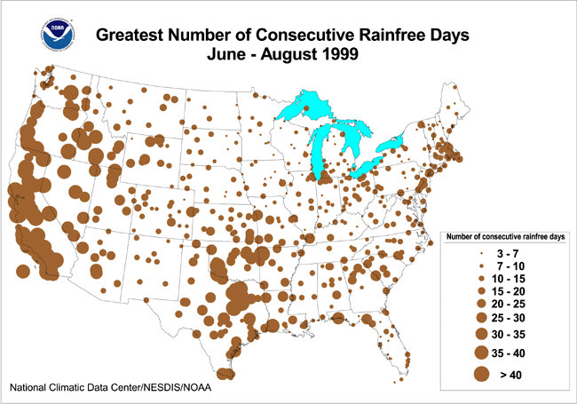
larger imageThe map to the left shows the greatest number of consecutive days during summer 1999 with no measureable precipitation and is useful in describing the summer's worst (or longest) dry spell. The summer dry spell was especially intense in the southern Plains, where some places went as long as 40 or more days with no rain. Dallas-Fort Worth, Texas, had 56 consecutive days with no measureable rainfall (July 11 - September 4), which was the third longest dry spell on record. Parts of the Southeast and New England had dry spells lasting 20 or more consecutive days. Long dry spells during this season are normal for much of the Far West, where summer is the dry season, and especially in the typically arid regions of the southwestern U.S., where rain rarely falls during the summer. This map is based on preliminary data.
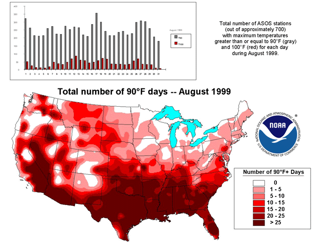
The Summer 1999 Heat Wave
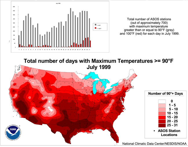
Unusually hot temperatures occurred with the drought in the eastern and south central U.S. The maps below show the geographical pattern of number of days with maximum temperatures of 90 degrees F or above in July and August 1999. The 90 degree days dominated the southern tier states, which is common in the summer. (The concentration of 90 degree days along the border between southern California and Nevada does not reflect the cooler mountainous locations due to the lack of stations in this network at those elevations.) The bar graph above the July map shows two distinct heat waves during the month. The heat wave that started about July 22nd built upon itself, with more stations reaching 100 degree temperatures (red bars) each day as the month drew to a close. The bar graph above the August map shows three distinct peaks (red bars) to that month's heat wave.
larger image
larger image
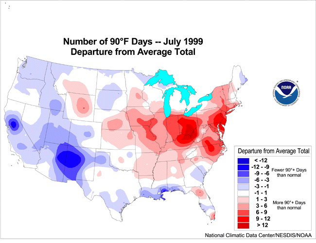
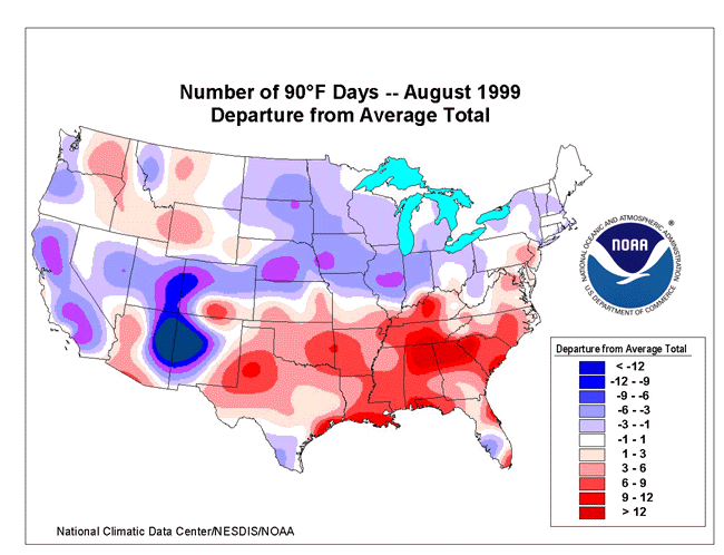
The maps below show the geographical pattern of the departure of these 90+ degree days from the 1961-1990 normal. The areas hardest hit by unusual warmth (red shading) in July stretched from the mid-Mississippi Valley to the mid-Atlantic states, then northward to New England. Some 232 deaths were attributed to the heat in the Midwest. The August heat was concentrated in the Southeast and southern Plains.
larger image
larger image
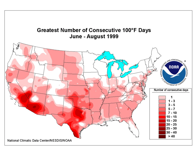
The map to the right shows the greatest number of consecutive days during summer 1999 with daily maximum temperature at least 100 degrees F and is useful in describing the summer's worst (or longest) heat wave. An unusually long heat wave occurred in the southern Plains, with Dallas-Fort Worth, Texas reporting 24 consecutive days with 100+ degree heat, the fourth longest such heat wave on record. Heat waves of shorter durations occurred from the Southeast to the northern Plains and in the Pacific Northwest (between troughs). Temperatures of 100 degrees or more are common every summer in the Desert Southwest.
larger image
The maps in this section are based on preliminary data.
Current data are based on preliminary reports from River Forecast Center stations and First and Second Order airport stations obtained from the National Weather Service (NWS) Climate Prediction Center and real time Global Telecommunications System (GTS) monthly CLIMAT summaries. THE CURRENT DATA SHOULD BE USED WITH CAUTION. These preliminary data are useful for estimating how current anomalies compare to the historical record, however the actual values and rankings for the current year may change as the final data arrive at NCDC and are processed.The following NCDC datasets are used for the historical U.S. data: the climate division drought database (TD-9640), and the hurricane datasets (TD-9636 and TD-9697). It should be noted that the climate division drought database consists of monthly data for 344 climate divisions in the contiguous United States. These divisional values are calculated from the 6000+ station Cooperative Observer network.